1960s Maps of Grant District, West Virginia
Explore 5 historic maps of Grant District from the 1960s. These maps offer a rare glimpse into what life looked like during the 1960s — showing old roads, neighborhoods, homes, and landmarks that have changed or disappeared over time.
Whether you're researching your family's past, planning a metal detecting trip, or studying how Grant District's landscape evolved across the 1960s, these high-resolution maps are a powerful tool for exploring the history of this region.
- Focus on a specific era: All maps on this page are from the 1960s, giving you a focused view of this time period.
- See what’s changed: Compare century-old streets, trails, and buildings to today's modern landscape using overlays and satellite layers.
- Research with precision: Use these maps for genealogy, historical research, land use analysis, or educational projects.
- View, download, or print: Maps are fully viewable online in high resolution, and can be downloaded or printed for your own records.
Start exploring Grant District's history through authentic maps from the 1960s. This is your window into the past.
Grant District, WV maps
(5)- 1960 Map of Wellsville, 1962 Print
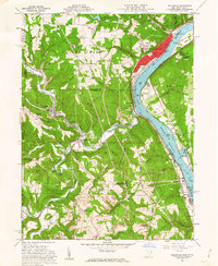 1960 Wellsville1962 Print · USGSThe Ohio River valley in the early sixties is a landscape of heavy industry and riverfront commerce. Genealogists can trace family plots at Spring Hill Cem or explore rail-side communities like Wellsville, Irondale, and Hammondsville.6 unique versions available
 - 1960 Map of East Liverpool North, 1962 Print
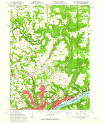 1960 East Liverpool North1962 Print · USGSThe industrial riverfront of the Ohio Valley meets the historic tri-state border lands in the early 1960s. Genealogists and historians can trace the geodetic history of the Geographers Line or locate family sites at Riverview Cemetery and Spring Grove.6 unique versions available
 - 1960 Map of East Liverpool South, 1962 Print
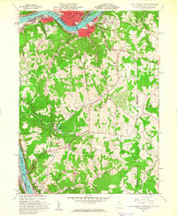 1960 East Liverpool South1962 Print · USGSThe Ohio River borderlands in the early sixties reveal a landscape of heavy industry and quiet ridge-top communities. Genealogists can trace family sites at Glendale Ch, the Locust Hill Cem, and the historic County Childrens Home.6 unique versions available
 - 1962 Map of Canton
 1962 Canton1962 Print · USGSThe industrial heartland of Eastern Ohio and Western Pennsylvania thrives in the early sixties as steel mills and rail lines dominate the river valleys. Genealogists and historians can trace local landmarks like McKinley National Memorial, Malone College, and industrial sites such as Republic Steel Corp.2 unique versions available
 - 1968 Map of Weirton, 1970 Print
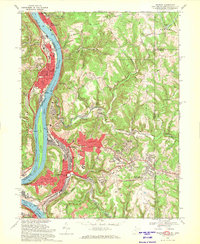 1968 Weirton1970 Print · USGSThe industrial corridor along the Ohio River is shown here at its mid-century peak during the late sixties. Genealogists and local historians can trace family locations through Union Cem, Sacred Heart of Mary Ch, and numerous neighborhood schools like Roosevelt Sch.3 unique versions available
End of results
Showing maps 1-5 of 5
Top cities near Grant District
- Weirton historical maps
- Steubenville historical maps
- East Liverpool historical maps
- Toronto historical maps
- Wellsville historical maps
- Wintersville historical maps
See more
Top neighborhoods of Grant District
- Congo historical maps
- Lennyville historical maps
- Moscow historical maps
- Fairhaven historical maps
- Brownsdale Mobile Home Park historical maps
- New Manchester historical maps
See more
Frequently asked questions
- What are the different types of historical maps available for Grant District?
- What is the oldest map of Grant District?
- Where can I purchase historical maps of Grant District for my home or office?
- Where can I download high-res historical maps of Grant District?
- Are there historical topographic maps available for Grant District?
- Is there historical aerial imagery available for Grant District?
- Where are historical maps of Grant District sourced from?