1960s Maps of Clarksburg, West Virginia
Explore 4 historic maps of Clarksburg from the 1960s. These maps offer a rare glimpse into what life looked like during the 1960s — showing old roads, neighborhoods, homes, and landmarks that have changed or disappeared over time.
Whether you're researching your family's past, planning a metal detecting trip, or studying how Clarksburg's landscape evolved across the 1960s, these high-resolution maps are a powerful tool for exploring the history of this region.
- Focus on a specific era: All maps on this page are from the 1960s, giving you a focused view of this time period.
- See what’s changed: Compare century-old streets, trails, and buildings to today's modern landscape using overlays and satellite layers.
- Research with precision: Use these maps for genealogy, historical research, land use analysis, or educational projects.
- View, download, or print: Maps are fully viewable online in high resolution, and can be downloaded or printed for your own records.
Start exploring Clarksburg's history through authentic maps from the 1960s. This is your window into the past.
Clarksburg, WV maps
(4)- 1960 Map of Wolf Summit, 1962 Print
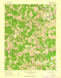 1960 Wolf Summit1962 Print · USGSCentral Harrison County in the early sixties remains a hub of rail and mining activity. Genealogists and historians can trace family locations through Olive Cem, the County Infirmary, and settlements like Wolf Summit or Sardis.2 unique versions available
 - 1960 Map of Rosemont, 1962 Print
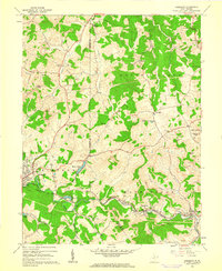 1960 Rosemont1962 Print · USGSTaylor and Harrison counties reflect a mid-century industrial peak as the coal-and-rail economy defined the hollows. Genealogists can trace family landmarks like Harmony Grove Ch, Old Side Cem, and the mining settlements of Rosemont and Baileytown.3 unique versions available
 - 1961 Map of Clarksburg
 1961 Clarksburg1961 Print · USGSThe mid-century industrial and river landscapes of West Virginia and Ohio are detailed here, centered on the Ohio River. Researchers can trace the Baltimore and Ohio rail lines connecting towns like Parkersburg, Clarksburg, and Monongah.
 - 1961 Map of Mount Clare, 1962 Print
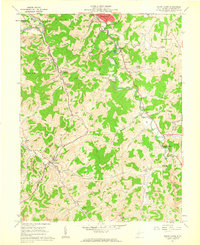 1961 Mount Clare1962 Print · USGSHarrison County in the early sixties showcases a landscape of coal tipples and country churches during the peak of the West Fork River valley's industrial era. Researchers can trace family history at Floral Hills Memorial Gardens or explore rail hubs like Mount Clare.3 unique versions available
End of results
Showing maps 1-4 of 4
Top cities near Clarksburg
- Fairmont historical maps
- Bridgeport historical maps
- Pleasant Valley historical maps
- Shinnston historical maps
- Mannington historical maps
- Salem historical maps
See more
Top neighborhoods of Clarksburg
- Broad Oaks historical maps
- Glen Elk historical maps
- Montpelier historical maps
- Stealey historical maps
- North View historical maps
- Adamston historical maps
See more
Frequently asked questions
- What are the different types of historical maps available for Clarksburg?
- What is the oldest map of Clarksburg?
- Where can I purchase historical maps of Clarksburg for my home or office?
- Where can I download high-res historical maps of Clarksburg?
- Are there historical topographic maps available for Clarksburg?
- Is there historical aerial imagery available for Clarksburg?
- Where are historical maps of Clarksburg sourced from?