1960s Maps of Fairmont, West Virginia
Explore 3 historic maps of Fairmont from the 1960s. These maps offer a rare glimpse into what life looked like during the 1960s — showing old roads, neighborhoods, homes, and landmarks that have changed or disappeared over time.
Whether you're researching your family's past, planning a metal detecting trip, or studying how Fairmont's landscape evolved across the 1960s, these high-resolution maps are a powerful tool for exploring the history of this region.
- Focus on a specific era: All maps on this page are from the 1960s, giving you a focused view of this time period.
- See what’s changed: Compare century-old streets, trails, and buildings to today's modern landscape using overlays and satellite layers.
- Research with precision: Use these maps for genealogy, historical research, land use analysis, or educational projects.
- View, download, or print: Maps are fully viewable online in high resolution, and can be downloaded or printed for your own records.
Start exploring Fairmont's history through authentic maps from the 1960s. This is your window into the past.
Fairmont, WV maps
(3)- 1960 Map of Grant Town, 1961 Print
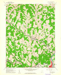 1960 Grant Town1961 Print · USGSMarion and Monongalia counties are shown here at the peak of the mid-century industrial era, where coal mining and gas extraction shaped the local economy. Genealogists and historians can trace family-named sites like Hood Cem, Mc Curdyville, and the Gilbor Ch along the winding Paw Paw Creek.2 unique versions available
 - 1960 Map of Rivesville, 1962 Print
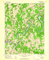 1960 Rivesville1962 Print · USGSThe Monongahela River valley was a bustling corridor of coal and rail in the early sixties. Genealogists and historians can trace family locations near the Site of Fort Prickett, the Montana Mines post office, and Snider Temple.4 unique versions available
 - 1961 Map of Clarksburg
 1961 Clarksburg1961 Print · USGSThe mid-century industrial and river landscapes of West Virginia and Ohio are detailed here, centered on the Ohio River. Researchers can trace the Baltimore and Ohio rail lines connecting towns like Parkersburg, Clarksburg, and Monongah.
End of results
Showing maps 1-3 of 3
Top cities near Fairmont
- Morgantown historical maps
- Clarksburg historical maps
- Bridgeport historical maps
- Grafton historical maps
- Westover historical maps
- Pleasant Valley historical maps
See more
Top neighborhoods of Fairmont
- Gaston historical maps
- Hillcrest historical maps
- Shagtown historical maps
- West End historical maps
- Beverly Hills historical maps
- Edgemont historical maps
See more
Frequently asked questions
- What are the different types of historical maps available for Fairmont?
- What is the oldest map of Fairmont?
- Where can I purchase historical maps of Fairmont for my home or office?
- Where can I download high-res historical maps of Fairmont?
- Are there historical topographic maps available for Fairmont?
- Is there historical aerial imagery available for Fairmont?
- Where are historical maps of Fairmont sourced from?