1900-1909 Maps of McDowell County, West Virginia
Explore 2 historic maps of McDowell County from 1900-1909. These maps offer a rare glimpse into what life looked like during the 1900s — showing old roads, neighborhoods, homes, and landmarks that have changed or disappeared over time.
Whether you're researching your family's past, planning a metal detecting trip, or studying how McDowell County's landscape evolved across the 1900s, these high-resolution maps are a powerful tool for exploring the history of this region.
- Focus on a specific era: All maps on this page are from the 1900s, giving you a focused view of this time period.
- See what’s changed: Compare century-old streets, trails, and buildings to today's modern landscape using overlays and satellite layers.
- Research with precision: Use these maps for genealogy, historical research, land use analysis, or educational projects.
- View, download, or print: Maps are fully viewable online in high resolution, and can be downloaded or printed for your own records.
Start exploring McDowell County's history through authentic maps from the 1900s. This is your window into the past.
McDowell County, WV maps
(2)- 1909 Map of Pocahontas Special
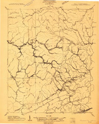 1909 Pocahontas Special1909 Print · USGSThe Pocahontas coalfields are at the peak of their industrial expansion in this early century survey. Genealogists and historians can trace rail-tied communities like Switchback P O, Bramwell, and the rural Bailey Chapel along the steep mountain ridges.
 - 1909 Map of Gilbert
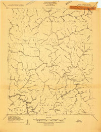 1909 Gilbert1909 Print · USGSSouthern West Virginia at the height of the coal and rail expansion is shown here through its dense network of river-valley settlements and mountain gaps. Genealogists can trace early homesteads and rail stops like Glenalum Sta, Wharncliffe, and Twisted Gun Gap.
End of results
Showing maps 1-2 of 2
Top cities of McDowell County
- Welch historical maps
- Gary historical maps
- War historical maps
- Northfork historical maps
- Keystone historical maps
- Raysal historical maps
See more
Frequently asked questions
- What are the different types of historical maps available for McDowell County?
- What is the oldest map of McDowell County?
- Where can I purchase historical maps of McDowell County for my home or office?
- Where can I download high-res historical maps of McDowell County?
- Are there historical topographic maps available for McDowell County?
- Is there historical aerial imagery available for McDowell County?
- Where are historical maps of McDowell County sourced from?