1920s Maps of Yukon, West Virginia
Explore 2 historic maps of Yukon from the 1920s. These maps offer a rare glimpse into what life looked like during the 1920s — showing old roads, neighborhoods, homes, and landmarks that have changed or disappeared over time.
Whether you're researching your family's past, planning a metal detecting trip, or studying how Yukon's landscape evolved across the 1920s, these high-resolution maps are a powerful tool for exploring the history of this region.
- Focus on a specific era: All maps on this page are from the 1920s, giving you a focused view of this time period.
- See what’s changed: Compare century-old streets, trails, and buildings to today's modern landscape using overlays and satellite layers.
- Research with precision: Use these maps for genealogy, historical research, land use analysis, or educational projects.
- View, download, or print: Maps are fully viewable online in high resolution, and can be downloaded or printed for your own records.
Start exploring Yukon's history through authentic maps from the 1920s. This is your window into the past.
Yukon, WV maps
(2)- 1924 Map of Welch, 1957 Print
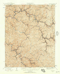 1924 Welch1957 Print · USGSSouthern West Virginia’s coal country is captured here during the 1920s, showing the height of the rail-and-mine economy. Researchers can trace the legacy of company towns and family homesteads near Welch, Coalwood, and the Warrior Mine.2 unique versions available
 - 1926 Map of Welch
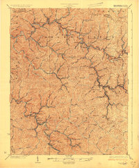 1926 Welch1926 Print · USGSMcDowell County's coal country comes alive in the mid-1920s, showing the height of the region's rail-and-river industrial development. Genealogists can pinpoint vanished post offices like Pando Juverna PO and old rural campuses such as Mill Creek School and Shannon Branch School.3 unique versions available
End of results
Showing maps 1-2 of 2
Top cities near Yukon
- Richlands historical maps
- Tazewell historical maps
- Welch historical maps
- Cedar Bluff historical maps
- Gary historical maps
- War historical maps
See more
Frequently asked questions
- What are the different types of historical maps available for Yukon?
- What is the oldest map of Yukon?
- Where can I purchase historical maps of Yukon for my home or office?
- Where can I download high-res historical maps of Yukon?
- Are there historical topographic maps available for Yukon?
- Is there historical aerial imagery available for Yukon?
- Where are historical maps of Yukon sourced from?