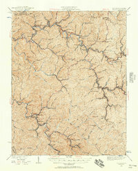
1924 Map of Welch
USGS Topo · Published 1957About this map
The Norfolk and Western RR carves through the narrow valleys of southern West Virginia, anchoring a network of coal towns and post offices during the mid-1920s. Centered on the hub of Welch, the landscape is defined by the tight confluence of Tug Fork and the Fork, where rail infrastructure supports dense settlement at Hemphill, Maitland, and Kimball. The map captures the industrial character of the era, from the Warrior Mine south of English to the company towns of Coalwood, Gary, and Thorpe. Genealogists will find significant detail in the placement of rural institutions like the Mill Creek School and Shannon Branch School, alongside vanished postal stops like Dry Fork Lomax PO and Dixopoca Superior PO. This survey documents the intense development of the Pocahontas Coalfield before later decades of consolidation altered the region's map.
Find a feature on this map
67 named features on this map. Tap any name to fly to it.
Don’t see what you’re looking for? This feature index may not catch every label — zoom into the map to look around manually.
Map Details
Editions of this 1924 Welch Map
2 editions found
Other maps of this area

1887 · Pocahontas
USGS Topo · 1:125,000

1891 · Tazewell
USGS Topo · 1:125,000

1891 · Pocahontas
USGS Topo · 1:125,000

1891 · Oceana
USGS Topo · 1:125,000

1891 · Raleigh
USGS Topo · 1:125,000

1893 · Oceana
USGS Topo · 1:125,000

1894 · Pocahontas
USGS Topo · 1:125,000

1895 · Tazewell
USGS Topo · 1:125,000

1895 · Pocahontas
USGS Topo · 1:125,000

1897 · Tazewell
USGS Topo · 1:125,000