1930s Maps of Nicholas County, West Virginia
Explore 5 historic maps of Nicholas County from the 1930s. These maps offer a rare glimpse into what life looked like during the 1930s — showing old roads, neighborhoods, homes, and landmarks that have changed or disappeared over time.
Whether you're researching your family's past, planning a metal detecting trip, or studying how Nicholas County's landscape evolved across the 1930s, these high-resolution maps are a powerful tool for exploring the history of this region.
- Focus on a specific era: All maps on this page are from the 1930s, giving you a focused view of this time period.
- See what’s changed: Compare century-old streets, trails, and buildings to today's modern landscape using overlays and satellite layers.
- Research with precision: Use these maps for genealogy, historical research, land use analysis, or educational projects.
- View, download, or print: Maps are fully viewable online in high resolution, and can be downloaded or printed for your own records.
Start exploring Nicholas County's history through authentic maps from the 1930s. This is your window into the past.
Nicholas County, WV maps
(5)- 1931 Map of Fayetteville
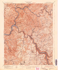 1931 Fayetteville1931 Print · USGSThe convergence of the New and Gauley rivers at the start of the 1930s reveals a bustling rail and coal corridor. Trace the path of the New York Central Railroad through mountain hamlets like Gauley Bridge, Nuttallburg, and South Caperton.3 unique versions available
 - 1935 Map of Lobelia, 1959 Print
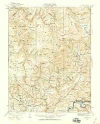 1935 Lobelia1959 Print · USGSThe Greenbrier County backcountry is shown in the mid-1930s, just as the regional forest service infrastructure was expanding. Genealogists and historians can trace numerous rural schoolhouses and churches, from Beulah Church to the Baldwin School and the remote Trout PO.2 unique versions available
 - 1935 Map of Richwood, 1962 Print
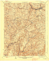
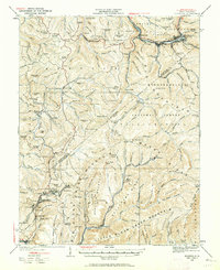 1935 Richwood1962 Print · USGSRichwood and the surrounding coal and timber lands of Nicholas and Greenbrier Counties are shown here in the mid-1930s. Researchers can trace the early industrial footprint of the Chesapeake and Ohio railroad through mountain settlements like Quinwood, Saxman, and Marfrance.2 unique versions available
 - 1939 Map of Lobelia
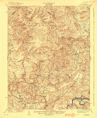 1939 Lobelia1939 Print · USGSGreenbrier and Pocahontas counties appear here in the years before the war, characterized by high mountain plateaus and a dense network of rural schoolhouses. Researchers can trace family roots through sites like Rockcamp Cem, Bethel Church, and the Trout Valley Trout Post Office.2 unique versions available
 - 1939 Map of Richwood
 1939 Richwood1939 Print · USGSThe West Virginia coal and timber country around Richwood and Quinwood is shown here during its industrial peak. Researchers can trace the Chesapeake and Ohio RR to remote hollows and find lost schools and churches like Bamboo School and Mountain Chapel.2 unique versions available
End of results
Showing maps 1-5 of 5
Top cities of Nicholas County
- Summersville historical maps
- Richwood historical maps
- Craigsville historical maps
- Persinger Ford historical maps
- Groves Ford historical maps
Frequently asked questions
- What are the different types of historical maps available for Nicholas County?
- What is the oldest map of Nicholas County?
- Where can I purchase historical maps of Nicholas County for my home or office?
- Where can I download high-res historical maps of Nicholas County?
- Are there historical topographic maps available for Nicholas County?
- Is there historical aerial imagery available for Nicholas County?
- Where are historical maps of Nicholas County sourced from?