1970s Maps of Nicholas County, West Virginia
Explore 5 historic maps of Nicholas County from the 1970s. These maps offer a rare glimpse into what life looked like during the 1970s — showing old roads, neighborhoods, homes, and landmarks that have changed or disappeared over time.
Whether you're researching your family's past, planning a metal detecting trip, or studying how Nicholas County's landscape evolved across the 1970s, these high-resolution maps are a powerful tool for exploring the history of this region.
- Focus on a specific era: All maps on this page are from the 1970s, giving you a focused view of this time period.
- See what’s changed: Compare century-old streets, trails, and buildings to today's modern landscape using overlays and satellite layers.
- Research with precision: Use these maps for genealogy, historical research, land use analysis, or educational projects.
- View, download, or print: Maps are fully viewable online in high resolution, and can be downloaded or printed for your own records.
Start exploring Nicholas County's history through authentic maps from the 1970s. This is your window into the past.
Nicholas County, WV maps
(5)- 1972 Map of Nettie, 1974 Print
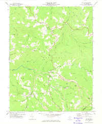 1972 Nettie1974 Print · USGSNettie and the Nicholas County highlands are mapped here in the early 1970s during a period of active coal production. Researchers can locate family-named landmarks like Fields Cem, rural congregations at Mt Zion Ch, and the industrial footprint of numerous local Strip Mines.2 unique versions available
 - 1972 Map of Quinwood, 1974 Print
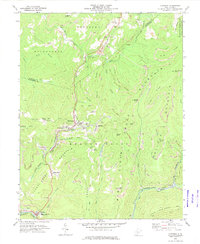 1972 Quinwood1974 Print · USGSThe West Virginia coal country of Greenbrier and Nicholas counties is captured here in the early seventies, dominated by the timber and mining industries. Researchers can trace the rail-reliant settlements of Quinwood, Leslie, and Anjean, or locate family landmarks like Bridge Ch and the Drive-in Theater.2 unique versions available
 - 1972 Map of Richwood, 1975 Print
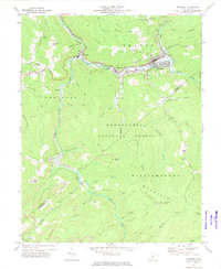 1972 Richwood1975 Print · USGSRichwood and the Cherry River valley are captured here in the early seventies during a period of active mountain industry. Genealogists and local historians can trace old homesteads and family sites like Baber Cem, Lynn Low Place, and the New Hope Sch.3 unique versions available
 - 1977 Map of Fork Mountain, 1978 Print
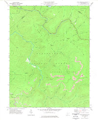 1977 Fork Mountain1978 Print · USGSGreenbrier County’s rugged highland interior is captured here in the late seventies as industrial mining expanded across the Monongahela National Forest. Researchers can find land-use patterns through numerous Strip Mine locations and family-named features like Manning Knob or the local Cem.2 unique versions available
 - 1979 Map of Marlinton, 1982 Print
 1979 Marlinton1982 Print · USGSThe West Virginia highlands are shown in detail during the late seventies, featuring the dense rail networks and mountain towns of the Allegheny range. Researchers can trace family roots through sites like Buckeye Cem, Mount Nebo Ch, and the lumber and coal hubs of Richwood and Rainelle.
End of results
Showing maps 1-5 of 5
Top cities of Nicholas County
- Summersville historical maps
- Richwood historical maps
- Craigsville historical maps
- Persinger Ford historical maps
- Groves Ford historical maps
Frequently asked questions
- What are the different types of historical maps available for Nicholas County?
- What is the oldest map of Nicholas County?
- Where can I purchase historical maps of Nicholas County for my home or office?
- Where can I download high-res historical maps of Nicholas County?
- Are there historical topographic maps available for Nicholas County?
- Is there historical aerial imagery available for Nicholas County?
- Where are historical maps of Nicholas County sourced from?