1970s Maps of Pendleton County, West Virginia
Explore 2 historic maps of Pendleton County from the 1970s. These maps offer a rare glimpse into what life looked like during the 1970s — showing old roads, neighborhoods, homes, and landmarks that have changed or disappeared over time.
Whether you're researching your family's past, planning a metal detecting trip, or studying how Pendleton County's landscape evolved across the 1970s, these high-resolution maps are a powerful tool for exploring the history of this region.
- Focus on a specific era: All maps on this page are from the 1970s, giving you a focused view of this time period.
- See what’s changed: Compare century-old streets, trails, and buildings to today's modern landscape using overlays and satellite layers.
- Research with precision: Use these maps for genealogy, historical research, land use analysis, or educational projects.
- View, download, or print: Maps are fully viewable online in high resolution, and can be downloaded or printed for your own records.
Start exploring Pendleton County's history through authentic maps from the 1970s. This is your window into the past.
Pendleton County, WV maps
(2)- 1970 Map of Sinks of Gandy, 1973 Print
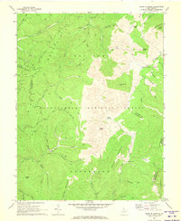 1970 Sinks of Gandy1973 Print · USGSThe Allegheny Mountains around Osceola and the Sinks of Gandy appear here in the early seventies, spanning three West Virginia counties. Researchers can trace remote mountain geography including the Blister Swamp, The Pigs Ear, and several family-named landmarks like Yokum Knob.2 unique versions available
 - 1970 Map of Spruce Knob, 1973 Print
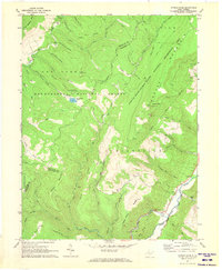 1970 Spruce Knob1973 Print · USGSThe West Virginia highlands around Cherry Grove are documented here in the early 1970s, showcasing the state's highest peak. Researchers can trace family landmarks and rural life through Big Run Chapel, Spruce Knob Lookout Tower, and Spruce Knob Lake.
End of results
Showing maps 1-2 of 2
Top cities of Pendleton County
Frequently asked questions
- What are the different types of historical maps available for Pendleton County?
- What is the oldest map of Pendleton County?
- Where can I purchase historical maps of Pendleton County for my home or office?
- Where can I download high-res historical maps of Pendleton County?
- Are there historical topographic maps available for Pendleton County?
- Is there historical aerial imagery available for Pendleton County?
- Where are historical maps of Pendleton County sourced from?