1990s Maps of Beulah, West Virginia
Explore 1 historic maps of Beulah from the 1990s. These maps offer a rare glimpse into what life looked like during the 1990s — showing old roads, neighborhoods, homes, and landmarks that have changed or disappeared over time.
Whether you're researching your family's past, planning a metal detecting trip, or studying how Beulah's landscape evolved across the 1990s, these high-resolution maps are a powerful tool for exploring the history of this region.
- Focus on a specific era: All maps on this page are from the 1990s, giving you a focused view of this time period.
- See what’s changed: Compare century-old streets, trails, and buildings to today's modern landscape using overlays and satellite layers.
- Research with precision: Use these maps for genealogy, historical research, land use analysis, or educational projects.
- View, download, or print: Maps are fully viewable online in high resolution, and can be downloaded or printed for your own records.
Start exploring Beulah's history through authentic maps from the 1990s. This is your window into the past.
Beulah, WV maps
(1)- 1995 Map of Beverly East, 1998 Print
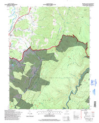 1995 Beverly East1998 Print · USGSThe Randolph County highlands are captured here in the mid-1990s as the river-and-rail landscape of the Alleghenies continues to evolve. Genealogists and hikers can trace the Allegheny Trail through the Monongahela National Forest and locate points like Elk River Junction or Hazelwood.
End of results
Showing maps 1-1 of 1
Top cities near Beulah
- Elkins historical maps
- Beverly historical maps
- Mill Creek historical maps
- Valley Bend historical maps
- East Dailey historical maps
- Junior historical maps
See more
Frequently asked questions
- What are the different types of historical maps available for Beulah?
- What is the oldest map of Beulah?
- Where can I purchase historical maps of Beulah for my home or office?
- Where can I download high-res historical maps of Beulah?
- Are there historical topographic maps available for Beulah?
- Is there historical aerial imagery available for Beulah?
- Where are historical maps of Beulah sourced from?