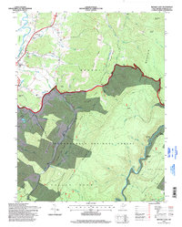
1995 Map of Beverly East
USGS Topo · Published 1998About this map
Cheat Mountain dominates the center of this terrain, where the high-altitude headwaters of the Shavers Fork and Tygart Valley River carve through the Monongahela National Forest. In the western valley, the settlement of Beverly and nearby Hazelwood sit along the riverbanks, serving as a gateway to the steep ridges of Limekiln Ridge and Millstone Ridge. This map captures a landscape defined by its rail history and logging heritage, marked by remote points like Elk River Junction and Cheat Junction deep within the forest interior. Cultural landmarks such as Camp Pioneer and the Mt Carmel Ch highlight the community clusters near Files Creek, while the Allegheny Trail provides a continuous thread through the high ridges of the Cheat Mountain National Forest. The presence of several distinct water features, including the High Falls and Scott Lake, illustrates the complex drainage patterns of the Allegheny Highlands.
Find a feature on this map
54 named features on this map. Tap any name to fly to it.
Don’t see what you’re looking for? This feature index may not catch every label — zoom into the map to look around manually.
Map Details
Editions of this 1995 Beverly East Map
This is the sole edition of this map. No revisions or reprints were ever made.
Other maps of this area

1889 · Beverly
USGS Topo · 1:125,000

1892 · Beverly
USGS Topo · 1:125,000

1909 · Elkins
USGS Topo · 1:62,500

1922 · Horton
USGS Topo · 1:48,000

1922 · Spruce Knob
USGS Topo · 1:48,000

1922 · Durbin
USGS Topo · 1:48,000

1924 · Durbin
USGS Topo · 1:62,500

1924 · Horton
USGS Topo · 1:62,500

1924 · Spruce Knob
USGS Topo · 1:62,500

1949 · Charlottesville
USGS Topo · 1:250,000