1900-1909 Maps of Ritchie County, West Virginia
Explore 6 historic maps of Ritchie County from 1900-1909. These maps offer a rare glimpse into what life looked like during the 1900s — showing old roads, neighborhoods, homes, and landmarks that have changed or disappeared over time.
Whether you're researching your family's past, planning a metal detecting trip, or studying how Ritchie County's landscape evolved across the 1900s, these high-resolution maps are a powerful tool for exploring the history of this region.
- Focus on a specific era: All maps on this page are from the 1900s, giving you a focused view of this time period.
- See what’s changed: Compare century-old streets, trails, and buildings to today's modern landscape using overlays and satellite layers.
- Research with precision: Use these maps for genealogy, historical research, land use analysis, or educational projects.
- View, download, or print: Maps are fully viewable online in high resolution, and can be downloaded or printed for your own records.
Start exploring Ritchie County's history through authentic maps from the 1900s. This is your window into the past.
Ritchie County, WV maps
(6)- 1904 Map of Marietta, 1923 Print
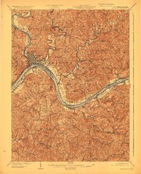 1904 Marietta1923 Print · USGSThe riverfront communities of the Ohio Valley come to life in this early 1900s survey of the border region. Trace the historic Steamboat Route past Kerr Island or locate ancestral homes in rural Valley Mills and Stanleyville.
 - 1905 Map of West Union
 1905 West Union1905 Print · USGSDoddridge and Tyler Counties come to life at the turn of the century as the railroad and river define the local economy. Genealogists can trace family footprints near Josephs Mills, The Jug, and the early post offices at Little PO and Centerville Alma PO.2 unique versions available
 - 1906 Map of Saint Marys
 1906 Saint Marys1906 Print · USGSThe riverfront around St Marys and the Ohio River islands is captured here in the early 1900s. Genealogists and researchers can trace early rural life through landmarks like Ninemile Schoolhouse, Union Mills, and the Baltimore and Ohio RR corridor.3 unique versions available
 - 1906 Map of Holbrook
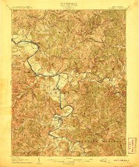
 1906 Holbrook1906 Print · USGSRitchie County and the surrounding highlands are captured here at the dawn of the twentieth century. Genealogists can trace family names and early homesteads near Burnt House, the Staunton and Parkersburg Pike, and the village of Pullman.2 unique versions available
 - 1906 Map of Elizabeth
 1906 Elizabeth1906 Print · USGSWirt and Wood Counties come alive in the first decade of the twentieth century, anchored by the river commerce of the Little Kanawha River. Genealogists and historians can trace defunct post offices and rail stops like Dulin PO, Volcano Junction, and Kanawha Station.2 unique versions available
 - 1907 Map of Harrisville
 1907 Harrisville1907 Print · USGSRitchie County at the start of the twentieth century is centered on the rugged valleys of the North Fork and South Fork Hughes River. Researchers can trace the path of the Baltimore and Ohio RR and locate rural hubs like Silver Run Station and the Ritchie Mine.2 unique versions available
End of results
Showing maps 1-6 of 6
Top cities of Ritchie County
- Harrisville historical maps
- Pennsboro historical maps
- Ellenboro historical maps
- Cairo historical maps
- Pullman historical maps
- Auburn historical maps
Frequently asked questions
- What are the different types of historical maps available for Ritchie County?
- What is the oldest map of Ritchie County?
- Where can I purchase historical maps of Ritchie County for my home or office?
- Where can I download high-res historical maps of Ritchie County?
- Are there historical topographic maps available for Ritchie County?
- Is there historical aerial imagery available for Ritchie County?
- Where are historical maps of Ritchie County sourced from?