Old Maps of Ritchie County, West Virginia for Academic Research
Study the evolution of Ritchie County with 121 high-resolution historic maps. Whether you're teaching, researching, or modeling changes in land use, these maps provide essential visual documentation of urban, environmental, and geographic change.
- Analyze long-term change: Track patterns in development, transportation, and natural features.
- Ideal for environmental or urban studies: Support academic projects with primary historical map data.
- Use in the classroom or lab: Educators and researchers rely on these maps to bring historical context to life.
These maps are a powerful tool for teaching, research, and visualizing how Ritchie County has changed over the decades.
Ritchie County, WV maps
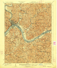
(121)- 1904 Map of Marietta, 1923 Print
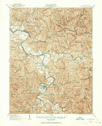
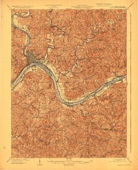 1904 Marietta1923 Print · USGSThe riverfront communities of the Ohio Valley come to life in this early 1900s survey of the border region. Trace the historic Steamboat Route past Kerr Island or locate ancestral homes in rural Valley Mills and Stanleyville.
 - 1905 Map of West Union
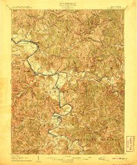
 1905 West Union1905 Print · USGSDoddridge and Tyler Counties come to life at the turn of the century as the railroad and river define the local economy. Genealogists can trace family footprints near Josephs Mills, The Jug, and the early post offices at Little PO and Centerville Alma PO.2 unique versions available
 - 1906 Map of Saint Marys
 1906 Saint Marys1906 Print · USGSThe riverfront around St Marys and the Ohio River islands is captured here in the early 1900s. Genealogists and researchers can trace early rural life through landmarks like Ninemile Schoolhouse, Union Mills, and the Baltimore and Ohio RR corridor.3 unique versions available
 - 1906 Map of Holbrook
 1906 Holbrook1906 Print · USGSRitchie County and the surrounding highlands are captured here at the dawn of the twentieth century. Genealogists can trace family names and early homesteads near Burnt House, the Staunton and Parkersburg Pike, and the village of Pullman.2 unique versions available
 - 1906 Map of Elizabeth
 1906 Elizabeth1906 Print · USGSWirt and Wood Counties come alive in the first decade of the twentieth century, anchored by the river commerce of the Little Kanawha River. Genealogists and historians can trace defunct post offices and rail stops like Dulin PO, Volcano Junction, and Kanawha Station.2 unique versions available
 - 1907 Map of Harrisville
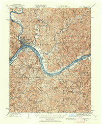
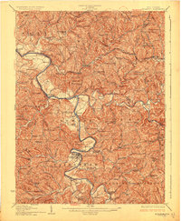
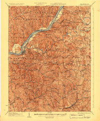
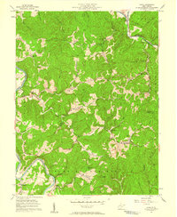
 1907 Harrisville1907 Print · USGSRitchie County at the start of the twentieth century is centered on the rugged valleys of the North Fork and South Fork Hughes River. Researchers can trace the path of the Baltimore and Ohio RR and locate rural hubs like Silver Run Station and the Ritchie Mine.2 unique versions available
 - 1924 Map of St Marys, 1956 Print
 1924 St Marys1956 Print · USGSPleasants County and the Ohio River valley are shown here in the mid-twenties, just as the local rail and river networks reached their peak. Genealogists can trace hundreds of family sites near St Marys, including Bibbys Chapel, Ellenboro, and the Willow Island School.
 - 1924 Map of Harrisville, 1957 Print
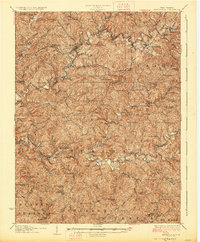
 1924 Harrisville1957 Print · USGSRitchie County during the mid-1920s reveals a landscape of ridge-top schools and river-valley industry. Genealogists can trace family roots through numerous local landmarks like Silver Run Sta Donohue PO, Ritchie Mines, and Star Settlement.
 - 1924 Map of West Union, 1961 Print
 1924 West Union1961 Print · USGSThe hills of Tyler and Doddridge Counties are shown here during the mid-twenties, centered on the winding Middle Island Creek and the busy rail corridor. Genealogists can trace family landmarks like Mole Hill, Josephs Mills, and dozens of local schools from Rising Sun to Chestnut Grove.
 - 1924 Map of Holbrook, 1961 Print
 1924 Holbrook1961 Print · USGSNorth-central West Virginia at the height of its rural settlement density reveals a landscape of ridge-top knobs and narrow hollows. Genealogists and historians can trace dozens of family-named landmarks and local institutions, from Mt Union Church to the many schools like Alum Fork School and Moonrise School.
 - 1924 Map of Marietta, 1962 Print
 1924 Marietta1962 Print · USGSThe Ohio River borderlands near the Muskingum confluence are captured here in the 1920s, showing a landscape of river-bend towns and hilltop farmsteads. Researchers can trace historic schools and rural meeting places like Rising Sun School, Social Chapel, and the Baltimore and Ohio RR line.
 - 1924 Map of Elizabeth, 1965 Print
 1924 Elizabeth1965 Print · USGSWirt and Wood Counties come alive in the mid-1920s as the Little Kanawha River serves as the primary artery for local life and industry. Genealogists can trace hundreds of family sites near schools like Mountain Flower School or the rural Antioch Church.
 - 1926 Map of Elizabeth
 1926 Elizabeth1926 Print · USGSMid-century West Virginia hill country comes to life here along the banks of the Little Kanawha River and the Baltimore and Ohio line. Genealogists can trace a remarkable landscape of rural education through Rising Sun School, Mountain Flower School, and Muddy Cut School.3 unique versions available
 - 1926 Map of Harrisville
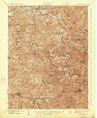
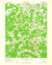
 1926 Harrisville1926 Print · USGSRitchie County in the mid-twenties is a landscape of winding river valleys and bustling rail hubs like Cairo and Harrisville. Researchers can trace the heritage of remote hill communities through dozens of local landmarks like the Ritchie Mine, Donohue PO, and Star Settlement.
 - 1926 Map of Holbrook
 1926 Holbrook1926 Print · USGSRitchie and Gilmer Counties are shown here in the mid-1920s, before modern highways altered these mountain valleys. Genealogists can trace family names across dozens of rural institutions, from Fairview Church to the Coal Alum Fork School.2 unique versions available
 - 1926 Map of West Union
 1926 West Union1926 Print · USGSDoddridge and Tyler counties are captured here in the mid-1920s, showing a landscape of ridge-top farms and creek-bottom settlements. You can trace the Baltimore and Ohio rail line or locate ancestral sites like Josephs Mills, Mole Hill, and Rising Sun School.3 unique versions available
 - 1927 Map of Marietta
 1927 Marietta1927 Print · USGSThe Mid-Ohio Valley comes alive in this mid-1920s survey of the river confluence at the Ohio River. Genealogists can trace family roots through numerous country schools and churches like Last Chance School and Shiloh Church.3 unique versions available
 - 1927 Map of Saint Marys
 1927 Saint Marys1927 Print · USGSPleasants and Ritchie counties come into focus during the mid-twenties as the Baltimore and Ohio railroad skirts the Ohio River. Researchers can trace ancestral locations through dozens of rural landmarks, from the Northwestern Turnpike to the Willow Island School and Mt Carmel Church.3 unique versions available
 - 1949 Map of Clarksburg
 1949 Clarksburg1949 Print · USGSThe upper Ohio River valley and the industrial heart of West Virginia come into focus during this post-war period. Genealogists and researchers can trace the rail corridors of the Baltimore and Ohio and locate centers like Fairmont, Grafton, and Waynesburg.
 - 1956 Map of Clarksburg, 1966 Print
 1956 Clarksburg1966 Print · USGSThe Ohio River valley and the industrial heart of West Virginia are seen here in the mid-1950s as rail and river commerce thrived. Researchers can trace historic transport lines like the Baltimore and Ohio RR and locate ancestral homes in Clarksburg, Moundsville, or Parkersburg.2 unique versions available
 - 1957 Map of Willow Island, 1958 Print
 1957 Willow Island1958 Print · USGSThe Ohio River valley and its industrial backcountry come into focus in the mid-1950s, showing a landscape of oil wells and river-rail transport. Trace ancestral roots at Middle Ridge Ch, Pumpkin Knob Sch, or the sprawling Volcano Oil Field.3 unique versions available
 - 1957 Map of Petroleum, 1958 Print
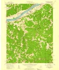
 1957 Petroleum1958 Print · USGSIn the mid-1950s, the borders of Wood, Ritchie, and Wirt Counties were defined by a landscape of energy extraction and rail transport. Researchers can trace family roots at Mt Carmel Ch, locate the Eaton Tunnel along the Baltimore and Ohio, or explore the namesake hills of Petroleum.4 unique versions available
 - 1957 Map of Girta, 1958 Print
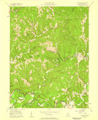
 1957 Girta1958 Print · USGSWirt and Ritchie Counties were centers of energy production in the late 1950s, defined by the winding river valleys and ridge-top settlements. Researchers can trace the extensive Burning Springs Oil Field and find family landmarks like Ruble Knob and Guthrie Ch.4 unique versions available
 - 1960 Map of Middlebourne, 1962 Print
 1960 Middlebourne1962 Print · USGSThe Tyler County hillsides and the sharp oxbows of Middle Island Creek are captured here in the early sixties. Genealogists can trace family roots through numerous upland burial sites like Archers Chapel Cem and the settlement at Bearsville.2 unique versions available
 - 1961 Map of Clarksburg
 1961 Clarksburg1961 Print · USGSThe mid-century industrial and river landscapes of West Virginia and Ohio are detailed here, centered on the Ohio River. Researchers can trace the Baltimore and Ohio rail lines connecting towns like Parkersburg, Clarksburg, and Monongah.
Showing maps 1-25 of 121
Top cities of Ritchie County
- Harrisville historical maps
- Pennsboro historical maps
- Ellenboro historical maps
- Cairo historical maps
- Pullman historical maps
- Auburn historical maps
Frequently asked questions
- What are the different types of historical maps available for Ritchie County?
- What is the oldest map of Ritchie County?
- Where can I purchase historical maps of Ritchie County for my home or office?
- Where can I download high-res historical maps of Ritchie County?
- Are there historical topographic maps available for Ritchie County?
- Is there historical aerial imagery available for Ritchie County?
- Where are historical maps of Ritchie County sourced from?