1990s Maps of Webster County, West Virginia
Explore 13 historic maps of Webster County from the 1990s. These maps offer a rare glimpse into what life looked like during the 1990s — showing old roads, neighborhoods, homes, and landmarks that have changed or disappeared over time.
Whether you're researching your family's past, planning a metal detecting trip, or studying how Webster County's landscape evolved across the 1990s, these high-resolution maps are a powerful tool for exploring the history of this region.
- Focus on a specific era: All maps on this page are from the 1990s, giving you a focused view of this time period.
- See what’s changed: Compare century-old streets, trails, and buildings to today's modern landscape using overlays and satellite layers.
- Research with precision: Use these maps for genealogy, historical research, land use analysis, or educational projects.
- View, download, or print: Maps are fully viewable online in high resolution, and can be downloaded or printed for your own records.
Start exploring Webster County's history through authentic maps from the 1990s. This is your window into the past.
Webster County, WV maps
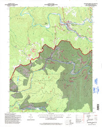
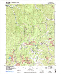
(13)- 1995 Map of Fork Mountain, 1998 Print
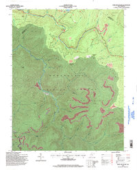 1995 Fork Mountain1998 Print · USGSThe West Virginia highlands in the 1990s show a landscape of intense resource extraction within the Monongahela National Forest. Trace the impact of several Strip Mines near landmarks like Cold Knob and Summit Lk.
 - 1995 Map of Samp, 1998 Print
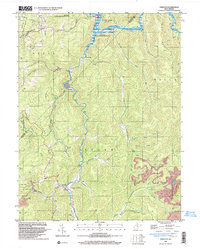
 1995 Samp1998 Print · USGSThe West Virginia highlands in the 1990s show a landscape where conservation and industry meet among the high ridges. Researchers can trace the river-centered settlements of Waneta and Samp or locate industrial sites like the Mill and several Strip Mines near Whitaker Falls.
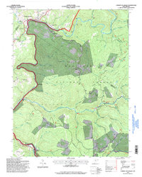
 - 1995 Map of Cowen, 1998 Print
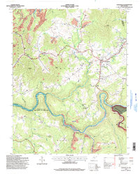
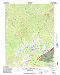 1995 Cowen1998 Print · USGSThe rail-and-timber country of Webster County is captured here in the mid-1990s, centering on the bustling junction at Cowen. Researchers can trace old mountain settlements at Wainville and Boggs, or locate family landmarks like Halo Ch and Little Glade Ch.
 - 1995 Map of Sharp Knob, 1998 Print
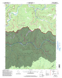
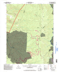 1995 Sharp Knob1998 Print · USGSThe West Virginia highlands in the mid-1990s show a landscape of resource extraction and mountain wilderness where three counties meet. Researchers can trace historic mining operations near Bergoo Creek or follow the Gauley Mountain Trail across Sharp Knob.
 - 1995 Map of Webster Springs, 1998 Print
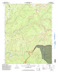
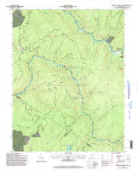
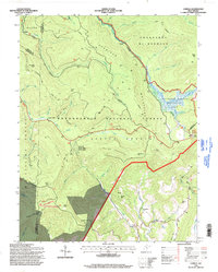
 1995 Webster Springs1998 Print · USGSWebster Springs and the surrounding mountain ridges are shown during the mid-1990s as the regional coal and timber industries continued to shape the land. Researchers can locate family landmarks like Lynch Point Cemetery, the Skidmore Crossing on the Elk, and the grounds of Camp Caesar.
 - 1995 Map of Camden on Gauley, 1998 Print
 1995 Camden on Gauley1998 Print · USGSThe Nicholas and Webster county border comes alive in the mid-nineties, showing a region defined by river gorges and timber tracks. Researchers can locate family landmarks like Half Acre Bethel Ch, Anderson Sch, and the Strip Mine Tipple near Holcomb.
 - 1995 Map of Bergoo, 1998 Print
 1995 Bergoo1998 Print · USGSThe West Virginia coalfields near the Webster and Pocahontas county line are captured here in the mid-1990s. Researchers can trace the industrial landscape of Bergoo and Jerryville alongside local landmarks like Pleasant Grove Ch and the Meadowland Cem.
 - 1995 Map of Webster Springs SW, 1998 Print
 1995 Webster Springs SW1998 Print · USGSThe Monongahela National Forest highlands are captured here in the mid-nineties, showing a landscape of rugged mountain peaks and river headwaters. Researchers can trace the Mills Mtn Ch, local Cem, and the remote Three Forks of Williams River.
 - 1995 Map of Craigsville, 1998 Print
 1995 Craigsville1998 Print · USGSNicholas County settlements and the winding Gauley River corridor are shown here in the mid-1990s as the local economy balanced industry and recreation. Genealogists and local historians can locate the Drive-in Theater at Craigsville, family cemeteries near Calvin, and the old Coal Siding along the river.
 - 1995 Map of Webster Springs SE, 1998 Print
 1995 Webster Springs SE1998 Print · USGSPocahontas County is shown here in the 1990s as a high-elevation backcountry where the Cranberry Wilderness preserves the headwaters of the Williams River. Researchers can trace old mountain paths like the Big Beechy Trail and find uniquely named landmarks such as Bannock Shoals.
 - 1995 Map of Lobelia, 1998 Print
 1995 Lobelia1998 Print · USGSPocahontas County in the mid-nineties shows a landscape of high-elevation wilderness and small forest communities. Trace the roads through Lobelia to find Emmanuel Ch or explore the unique terrain of the Cranberry Glades Botanical Area.
 - 1997 Map of Tioga, 2003 Print
 1997 Tioga2003 Print · USGSNicholas County’s coal and timber country is documented here in the late twentieth century, centered on the community of Tioga. Genealogists and local historians can locate family landmarks such as Radcliff Chapel, Boggs Cem, and the various mines that shaped the local economy.
 - 1997 Map of Erbacon, 2003 Print
 1997 Erbacon2003 Print · USGSThe northern mountains of Webster and Braxton Counties are captured here in the late nineties, centered on the Elk River corridor. Researchers can locate the mountain communities of Centralia, Prestonia, and Erbacon, as well as the Cleveland Sch and Centralia Cem.
End of results
Showing maps 1-13 of 13
Top cities of Webster County
Frequently asked questions
- What are the different types of historical maps available for Webster County?
- What is the oldest map of Webster County?
- Where can I purchase historical maps of Webster County for my home or office?
- Where can I download high-res historical maps of Webster County?
- Are there historical topographic maps available for Webster County?
- Is there historical aerial imagery available for Webster County?
- Where are historical maps of Webster County sourced from?