1920s Maps of Ikes Fork, West Virginia
Explore 2 historic maps of Ikes Fork from the 1920s. These maps offer a rare glimpse into what life looked like during the 1920s — showing old roads, neighborhoods, homes, and landmarks that have changed or disappeared over time.
Whether you're researching your family's past, planning a metal detecting trip, or studying how Ikes Fork's landscape evolved across the 1920s, these high-resolution maps are a powerful tool for exploring the history of this region.
- Focus on a specific era: All maps on this page are from the 1920s, giving you a focused view of this time period.
- See what’s changed: Compare century-old streets, trails, and buildings to today's modern landscape using overlays and satellite layers.
- Research with precision: Use these maps for genealogy, historical research, land use analysis, or educational projects.
- View, download, or print: Maps are fully viewable online in high resolution, and can be downloaded or printed for your own records.
Start exploring Ikes Fork's history through authentic maps from the 1920s. This is your window into the past.
Ikes Fork, WV maps
(2)- 1925 Map of Gilbert
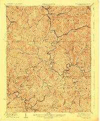 1925 Gilbert1925 Print · USGSSouthern West Virginia in the mid-twenties shows a landscape defined by steep hollows and a burgeoning coal-and-rail economy. Researchers can trace ancestral footprints at several family-named institutions like Hatfield School or find old mining hubs such as Wharncliffe and Glenalum.
 - 1927 Map of Gilbert
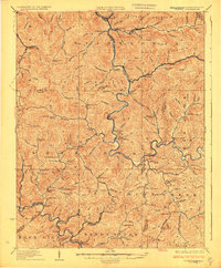 1927 Gilbert1927 Print · USGSIn the late 1920s, southern West Virginia's mountain hollows were connected by narrow-gauge rails and family-centered school districts. Genealogists can trace family footprints through sites like the Craig Hatfield School, Wharncliffe, and War Eagle.4 unique versions available
End of results
Showing maps 1-2 of 2
Top cities near Ikes Fork
- Welch historical maps
- Mallory historical maps
- Oceana historical maps
- Man historical maps
- War historical maps
- Bruno historical maps
See more
Frequently asked questions
- What are the different types of historical maps available for Ikes Fork?
- What is the oldest map of Ikes Fork?
- Where can I purchase historical maps of Ikes Fork for my home or office?
- Where can I download high-res historical maps of Ikes Fork?
- Are there historical topographic maps available for Ikes Fork?
- Is there historical aerial imagery available for Ikes Fork?
- Where are historical maps of Ikes Fork sourced from?