1960s Maps of Chippewa, Wisconsin
Explore 3 historic maps of Chippewa from the 1960s. These maps offer a rare glimpse into what life looked like during the 1960s — showing old roads, neighborhoods, homes, and landmarks that have changed or disappeared over time.
Whether you're researching your family's past, planning a metal detecting trip, or studying how Chippewa's landscape evolved across the 1960s, these high-resolution maps are a powerful tool for exploring the history of this region.
- Focus on a specific era: All maps on this page are from the 1960s, giving you a focused view of this time period.
- See what’s changed: Compare century-old streets, trails, and buildings to today's modern landscape using overlays and satellite layers.
- Research with precision: Use these maps for genealogy, historical research, land use analysis, or educational projects.
- View, download, or print: Maps are fully viewable online in high resolution, and can be downloaded or printed for your own records.
Start exploring Chippewa's history through authentic maps from the 1960s. This is your window into the past.
Chippewa, WI maps
(3)- 1968 Map of Glidden, 1971 Print
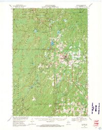 1968 Glidden1971 Print · USGSAshland and Iron County woods come to life in the late 1960s as the SOO LINE connects timber towns across a glacial landscape. Researchers can trace family roots at St Cecilia Cem or Morse Cem and locate vanished siding spots like Shanagolden and Popcorn Corners.
 - 1968 Map of Butternut, 1971 Print
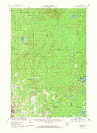 1968 Butternut1971 Print · USGSWisconsin's Northwoods come into focus in the late 1960s as a landscape defined by timber, rail, and water. Researchers can trace the Soo Line through Butternut, find the Union Cem, and locate river landmarks like Stubbs Rapids and Petes Landing.
 - 1968 Map of Park Falls, 1971 Print
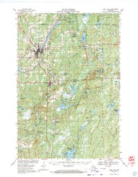 1968 Park Falls1971 Print · USGSPark Falls and Fifield sit at the heart of the northern timber country in the late sixties, where the Flambeau River meets a dense network of rail lines. Researchers can trace historic logging routes like the SMITH GRADE or locate local landmarks such as Nola Cem and Solberg Lake County Park.2 unique versions available
End of results
Showing maps 1-3 of 3
Top cities near Chippewa
- Fifield historical maps
- Morse historical maps
- Butternut historical maps
- Draper historical maps
- Shanagolden historical maps
Frequently asked questions
- What are the different types of historical maps available for Chippewa?
- What is the oldest map of Chippewa?
- Where can I purchase historical maps of Chippewa for my home or office?
- Where can I download high-res historical maps of Chippewa?
- Are there historical topographic maps available for Chippewa?
- Is there historical aerial imagery available for Chippewa?
- Where are historical maps of Chippewa sourced from?