1980s Maps of Chippewa, Wisconsin
Explore 6 historic maps of Chippewa from the 1980s. These maps offer a rare glimpse into what life looked like during the 1980s — showing old roads, neighborhoods, homes, and landmarks that have changed or disappeared over time.
Whether you're researching your family's past, planning a metal detecting trip, or studying how Chippewa's landscape evolved across the 1980s, these high-resolution maps are a powerful tool for exploring the history of this region.
- Focus on a specific era: All maps on this page are from the 1980s, giving you a focused view of this time period.
- See what’s changed: Compare century-old streets, trails, and buildings to today's modern landscape using overlays and satellite layers.
- Research with precision: Use these maps for genealogy, historical research, land use analysis, or educational projects.
- View, download, or print: Maps are fully viewable online in high resolution, and can be downloaded or printed for your own records.
Start exploring Chippewa's history through authentic maps from the 1980s. This is your window into the past.
Chippewa, WI maps
(6)- 1980 Map of Ironwood
 1980 Ironwood1980 Print · USGSThe Michigan-Wisconsin borderlands appear in the late twentieth century as a landscape defined by iron mining and deep forests. Researchers can trace the rail-and-river economy through the Soo Line and Chicago and North Western tracks connecting Mellen, Glidden, and Hurley.
 - 1980 Map of Park Falls
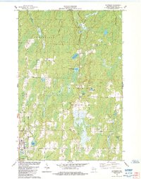
 1980 Park Falls1980 Print · USGSNorthern Wisconsin's timber and rail corridor is meticulously detailed here in the early eighties. Researchers can trace the Soo Line through forest-bound towns like Park Falls, Phillips, and Lugerville while exploring the vast Chequamegon National Forest.
 - 1984 Map of Butternut
 1984 Butternut1984 Print · USGSAshland County's Northwoods come into focus in the mid-eighties as the village of Butternut serves as a hub for local families and industries. Genealogists and researchers can trace lineage through family-named routes like Rominski Road and landmarks like the local Cemetery.
 - 1984 Map of Park Falls
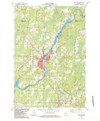 1984 Park Falls1984 Print · USGSPark Falls and the surrounding Northwoods landscape appear here during the mid-eighties, centered on the river's industrial power. Researchers can trace the Soo Line rail corridor, locate Nola Cem, and explore the settlement at Lymantown.
 - 1984 Map of Peeksville
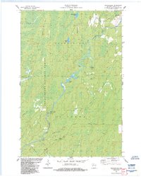
 1984 Peeksville1984 Print · USGSAshland County's timberlands and glacial lakes are shown here in the mid-1980s, centered on the Peeksville community. Researchers can trace the Old Railroad Grade, locate the St Cecelia Cem, or explore the many named backcountry routes like Mail Route Rd.
 - 1984 Map of Shanagolden
 1984 Shanagolden1984 Print · USGSWisconsin's Northwoods were characterized by deep forests and river-fed wetlands in the mid-1980s. Researchers can trace the winding East Fork Chippewa River and find local landmarks like Shanagolden, Pelican Lake, and the Stock Farm Bridge Recreation Site.2 unique versions available
End of results
Showing maps 1-6 of 6
Top cities near Chippewa
- Fifield historical maps
- Morse historical maps
- Butternut historical maps
- Draper historical maps
- Shanagolden historical maps
Frequently asked questions
- What are the different types of historical maps available for Chippewa?
- What is the oldest map of Chippewa?
- Where can I purchase historical maps of Chippewa for my home or office?
- Where can I download high-res historical maps of Chippewa?
- Are there historical topographic maps available for Chippewa?
- Is there historical aerial imagery available for Chippewa?
- Where are historical maps of Chippewa sourced from?