Old Maps of Bayfield County, Wisconsin for Hiking & Exploration
Hike through history with 158 historic maps of Bayfield County. Explore old trails, ghost towns, and forgotten backroads — perfect for outdoor adventurers and local explorers.
- Rediscover forgotten places: Map out old mining camps, roads, and footpaths that no longer exist on modern maps.
- Layer with modern tools: Combine with LiDAR or satellite views to plan hikes through historical terrain.
- Made for exploration: Popular among hikers, overlanders, and local history lovers.
Use these maps to find adventure and explore the hidden past of Bayfield County.
Bayfield County, WI maps
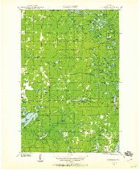
(158)- 1941 Map of Bayfield
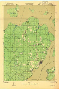
 1941 Bayfield1941 Print · USGSThe Apostle Islands and the Bayfield Peninsula are shown in the early 1940s, highlighting the intersection of indigenous lands and maritime industry. Trace ancestral roots at Red Cliff and La Pointe, or locate long-standing landmarks like the Raspberry LH and Sand Bay Sch.
 - 1942 Map of Ashland
 1942 Ashland1942 Print · USGSThe South Shore of Lake Superior comes alive in the early 1940s, showing the bustling rail hubs and maritime ports of Chequamegon Bay. Genealogists and historians can trace local family roots through sites like Northland College, St Agnes Cem, and Ondassagon Sch.
 - 1942 Map of Clam Lake, 1959 Print
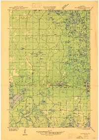
 1942 Clam Lake1959 Print · USGSNorthern Wisconsin's deep woods are captured here during the early 1940s, showing the early infrastructure of the Chequamegon National Forest. Researchers can locate the Clam Lake CCC Camp, the NYA Camp, and the Clam Lake Fire Tower among dozens of named lakes and streams.2 unique versions available
 - 1942 Map of Marengo, 1964 Print
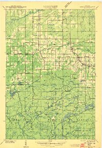
 1942 Marengo1964 Print · USGSNorthern Wisconsin's timber and rail landscape is captured here in the early 1940s, showing the intersection of federal forest land and tribal territory. Genealogists can locate specific rural schools like Maple Ridge Sch and communities like Sanborn or North York.
 - 1943 Map of Port Wing, 1952 Print
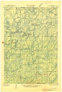
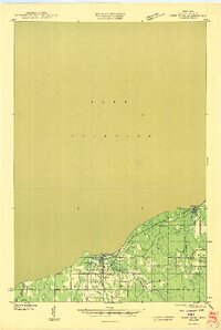
 1943 Port Wing1952 Print · USGSThe southern shore of Lake Superior comes into focus during the early 1940s, highlighting the coastal life and interior woodlands of Bayfield County. Researchers can trace the development of Port Wing and Herbster or locate family sites near Greenwood Cem and the Flag River.
 - 1943 Map of Iron Lake, 1952 Print
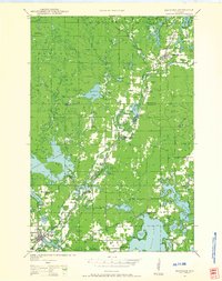
 1943 Iron Lake1952 Print · USGSBayfield County at the height of the 1940s reveals a landscape of lakeside settlements and rural school districts centered around Iron River. Genealogists and local researchers can trace early homesteads and landmarks like Hillside Cem, Washington Sch, and the Iron River Fire Tower.
 - 1943 Map of Namekagon Lake, 1960 Print
 1943 Namekagon Lake1960 Print · USGSUpper Wisconsin’s lake country is captured here during the mid-1940s, showing a landscape of glacial waters and early forest infrastructure. Researchers can locate remote schools and camps like Spider Lake Sch and the Sawyer CCC Camp or trace the early shoreline of Lost Land Lake.2 unique versions available
 - 1944 Map of Moquah, 1952 Print
 1944 Moquah1952 Print · USGSBayfield County at the end of the Second World War shows a landscape of timber-town history and rural school districts. Genealogists and historians can trace the foundations of Moquah, locate family-named schoolhouses like Gednota Sch, and follow the long-vanished Old Grade logging routes.2 unique versions available
 - 1944 Map of Cornucopia, 1952 Print
 1944 Cornucopia1952 Print · USGSThe Lake Superior shoreline near Cornucopia is shown here during the 1940s as a hub for coastal settlement and forest access. Genealogists can locate family landmarks like St Anthony Ch, Settlement Sch, and the docks of Cornucopia.
 - 1944 Map of Drummond, 1959 Print
 1944 Drummond1959 Print · USGSBayfield County’s forest and lake country is captured here in the mid-forties, centered on the mill town of Drummond. Genealogists and researchers can locate rural landmarks like Hall Sch, the Old Chippewa Camp Ground, and a legacy CCC Camp.2 unique versions available
 - 1944 Map of Grandview, 1962 Print
 1944 Grandview1962 Print · USGSBayfield County's Northwoods landscape is captured here during the mid-forties, showing the intricate network of rails and rural schools. Genealogists and historians can locate the Taylor Lake CCC Camp and trace family roots near Becker Sch, Grandview, and Mason.
 - 1944 Map of Hayward, 1965 Print
 1944 Hayward1965 Print · USGSHayward and the northern Wisconsin lake country are captured here at the close of the Second World War. Researchers can trace the Chicago St Paul Minneapolis and Omaha rail line to find vanished schoolhouses like Sabin Sch and the Indian Sch.
 - 1945 Map of Namekagon Lake
 1945 Namekagon Lake1945 Print · USGSThe National Forest of northern Wisconsin is shown here in the mid-1940s as a landscape of timber trails and remote camps. Researchers can locate the Sawyer CCC Camp, the Lost Land Lake Club, and local landmarks like the West Fork Fire Tower.2 unique versions available
 - 1945 Map of Marengo
 1945 Marengo1945 Print · USGSAshland County and the Chequamegon National Forest are captured here in the mid-1940s, showing a landscape shaped by timber and rail. Researchers can locate rural landmarks like Ebenezer Ch and vanished local schools including Agnew Sch and Section Five Sch.2 unique versions available
 - 1945 Map of Clam Lake
 1945 Clam Lake1945 Print · USGSThe Northwoods of Ashland and Bayfield Counties are captured here in the mid-1940s, centered on the Clam Lake community. Genealogists and historians can locate federal project sites like the Clam Lake CCC Camp and NYA Camp alongside the Clam Lake Fire Tower.2 unique versions available
 - 1945 Map of Highland, 1956 Print
 1945 Highland1956 Print · USGSNorthwestern Wisconsin at the end of the war is revealed here through its intricate network of glacial lakes and northern forests. Researchers can pinpoint mid-century local landmarks like the Frances Willard Sch, Barnes Cem, and the path of the Brule River.
 - 1946 Map of Cornucopia
 1946 Cornucopia1946 Print · USGSThe northern reaches of Bayfield County are captured here in the mid-1940s, highlighting the coastal community of Cornucopia. Researchers can trace old rural landmarks like the Settlement Sch, St Anthony Ch, and the numerous inlets of Bark Bay.
 - 1946 Map of Bayfield
 1946 Bayfield1946 Print · USGSThe Bayfield Peninsula and the Apostle Islands are shown here at the start of the 1940s, highlighting a rugged maritime and reservation landscape. Genealogists can locate family landmarks like Sunny Side, the Sanitarium at Pureair, and the Raspberry LH.
 - 1946 Map of Port Wing
 1946 Port Wing1946 Print · USGSThe Bayfield County coast along Lake Superior is captured in the mid-1940s just as early highway and utility networks were expanding. Researchers can locate family sites near Port Wing and Herbster, or trace old forest trails like T Tr 181L and the Greenwood Cem.
 - 1947 Map of Drummond
 1947 Drummond1947 Print · USGSBayfield County's timber and lake country comes into focus in the years following World War II. Researchers can locate remote schoolhouses like Hall Sch and Barnes Sch. or trace the footprint of the Delta CCC Camp (Abandoned).2 unique versions available
 - 1947 Map of Moquah
 1947 Moquah1947 Print · USGSBayfield County in the late 1940s reveals a landscape of rural schoolhouses and forest management hubs like the Brinks Ranger Sta. Genealogists and historians can trace family locations near Hillsdale Sch, Gednota Sch, and the rail stop at Ino Sta.
 - 1947 Map of Brule
 1947 Brule1947 Print · USGSDouglas and Bayfield counties are seen here in the mid-1940s, where the legendary trout waters of the Bois Brule River meet the Lake Superior shoreline. Genealogists and local historians can locate early homesteading landmarks like Rest Haven Cem, St Ann Ch, and the rural community hubs of Cloverland and Maple.2 unique versions available
 - 1947 Map of Iron Lake
 1947 Iron Lake1947 Print · USGSBayfield County at the end of the 1940s reveals a landscape of lakeside settlements and rural school districts linked by the Northern Pacific line. Researchers can trace local genealogy at Hillside Cem or locate former community sites like Kolin and Miles Sch.
 - 1947 Map of Ashland
 1947 Ashland1947 Print · USGSCoastal Wisconsin thrived on the shores of Lake Superior in the late 1940s, balancing industrial power with small-town education. Genealogists can trace family roots through numerous country schools like Olson Sch and local sites like St Agnes Cem.
 - 1947 Map of Grandview
 1947 Grandview1947 Print · USGSBayfield County at the close of the 1940s reveals a landscape of timber-towns and marshlands connected by the Chicago St Paul Minneapolis and Omaha rail line. Researchers can locate remote rural schoolhouses like Becker Sch and Dybedal Sch, or trace the winding course of the White River.
Showing maps 1-25 of 158
Top cities of Bayfield County
- Washburn historical maps
- Iron River historical maps
- Cable historical maps
- Bayfield historical maps
- Drummond historical maps
- Port Wing historical maps
See more
Frequently asked questions
- What are the different types of historical maps available for Bayfield County?
- What is the oldest map of Bayfield County?
- Where can I purchase historical maps of Bayfield County for my home or office?
- Where can I download high-res historical maps of Bayfield County?
- Are there historical topographic maps available for Bayfield County?
- Is there historical aerial imagery available for Bayfield County?
- Where are historical maps of Bayfield County sourced from?