1980s Maps of Bayfield County, Wisconsin
Explore 16 historic maps of Bayfield County from the 1980s. These maps offer a rare glimpse into what life looked like during the 1980s — showing old roads, neighborhoods, homes, and landmarks that have changed or disappeared over time.
Whether you're researching your family's past, planning a metal detecting trip, or studying how Bayfield County's landscape evolved across the 1980s, these high-resolution maps are a powerful tool for exploring the history of this region.
- Focus on a specific era: All maps on this page are from the 1980s, giving you a focused view of this time period.
- See what’s changed: Compare century-old streets, trails, and buildings to today's modern landscape using overlays and satellite layers.
- Research with precision: Use these maps for genealogy, historical research, land use analysis, or educational projects.
- View, download, or print: Maps are fully viewable online in high resolution, and can be downloaded or printed for your own records.
Start exploring Bayfield County's history through authentic maps from the 1980s. This is your window into the past.
Bayfield County, WI maps
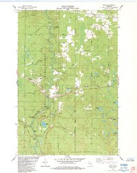
(16)- 1980 Map of Port Wing
 1980 Port Wing1980 Print · USGSThe Lake Superior shoreline and the deep forests of Bayfield and Douglas counties are captured here in the early eighties. Genealogists and historians can trace the rail lines through Iron River or locate the lakeside landings at Cornucopia and Port Wing.
 - 1980 Map of Ironwood
 1980 Ironwood1980 Print · USGSThe Michigan-Wisconsin borderlands appear in the late twentieth century as a landscape defined by iron mining and deep forests. Researchers can trace the rail-and-river economy through the Soo Line and Chicago and North Western tracks connecting Mellen, Glidden, and Hurley.
 - 1980 Map of Solon Springs
 1980 Solon Springs1980 Print · USGSNorthern Wisconsin in the early eighties was a landscape of dense timber and sprawling glacial waters. Trace the legacy of the Chicago and North Western rail line through Solon Springs, Hayward, and Minong at this pivotal moment.
 - 1984 Map of Sanborn
 1984 Sanborn1984 Print · USGSThe rural landscape of Ashland and Bayfield Counties in the mid-1980s reveals a quiet network of north woods settlements and timber history. Genealogists and local historians can trace family landmarks like Moe Cem and Moland Ch or follow the Old Railroad Grade through Sanborn.
 - 1984 Map of Iron Lake NE
 1984 Iron Lake NE1984 Print · USGSBayfield County's timber and water resources are mapped here in the mid-1980s during a period of forest management and conservation. Genealogists and local historians can trace family land via Larson Road or locate the National Fish Hatchery and Lenawee settlement.
 - 1984 Map of Marengo Lake
 1984 Marengo Lake1984 Print · USGSIn the mid-eighties, this northern Wisconsin wilderness served as a recreational and conservation hub within the Chequamegon National Forest. Hikers and historians can trace the North Country National Scenic Trail past landmarks like Morgan Falls and Trinity Ch.
 - 1984 Map of Ellison Lake
 1984 Ellison Lake1984 Print · USGSIn the mid-1980s, this portion of Douglas and Bayfield counties shows a dense network of water bodies and local township life. Researchers can trace family history at Barnes Cem or explore early land use near Mooney Dam County Park and the Lookout Tower.
 - 1984 Map of Oulu
 1984 Oulu1984 Print · USGSCoastal Douglas and Bayfield Counties meet the shore of Lake Superior here in the mid-1980s. Local researchers can trace family sites near Waino and Oulu, or locate landmarks along the famous Bois Brule River like Shale Falls and McNeil Landing.
 - 1984 Map of Brule
 1984 Brule1984 Print · USGSIn the mid-1980s, the Brule River valley was a landscape of forestry, fishing, and rail transit. Researchers can trace the Burlington Northern tracks as they pass through Brule or locate local landmarks like Pine Ridge Cem and the State Fish Hatchery.
 - 1984 Map of Iron Lake
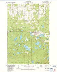 1984 Iron Lake1984 Print · USGSBayfield County in the mid-1980s reveals a dense network of glacial lakes and the bustling railroad town of Iron River. Genealogists and local historians can trace family locations near Oulu Sch, Grace Ch, and the Oulu Pioneer Memorial Park.2 unique versions available
 - 1984 Map of Blaine Creek
 1984 Blaine Creek1984 Print · USGSBayfield County's rural townships are shown in the mid-1980s, centered on the winding Iron River and its many tributaries. Genealogists can trace family footprints along Severson Road and Mannik Road, or locate the Hillside Cem and the Orienta Dam.
 - 1984 Map of Herbster
 1984 Herbster1984 Print · USGSThe Lake Superior shoreline near Herbster comes into focus in the mid-1980s, showcasing a landscape of state-managed fishery and wildlife areas. Researchers can trace family-named routes like Matthews Road and Lenawee Road through the Clover township.
 - 1984 Map of Hart Lake
 1984 Hart Lake1984 Print · USGSBayfield County in the mid-1980s is defined by its glacial lakes and the expansive reach of the Chequamegon National Forest. Researchers can trace the Burlington Northern rail line or locate local landmarks like Valley View Cem and the Iron River Lookout Tower.
 - 1984 Map of Island Lake
 1984 Island Lake1984 Print · USGSThe Brule River corridor and its famed whitewater rapids define this 1980s survey of the northern Wisconsin woods. Researchers can trace the layout of the Cedar Island Estate, locate the Brule Lookout Tower, and identify dozens of named glacial waters like Lucius Lake.
 - 1984 Map of Port Wing
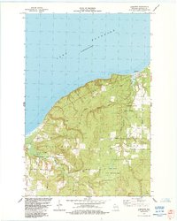
 1984 Port Wing1984 Print · USGSAlong the shores of Lake Superior in the early 1980s, this area shows the fishing and timber country surrounding Port Wing. Researchers can locate family landmarks like Greenwood Cem and trace the paths of the Flag River and Iron River.
 - 1989 Map of Ashland
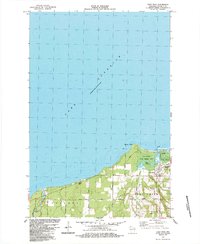
 1989 Ashland1989 Print · USGSCoastal Wisconsin and Michigan at the end of the 1980s show a landscape of deep-water bays, island preserves, and industrial timber towns. Researchers can trace the rail lines of the Soo Line and identify landmarks from Big Bay State Park to the Bad River Indian Reservation.
End of results
Showing maps 1-16 of 16
Top cities of Bayfield County
- Washburn historical maps
- Iron River historical maps
- Cable historical maps
- Bayfield historical maps
- Drummond historical maps
- Port Wing historical maps
See more
Frequently asked questions
- What are the different types of historical maps available for Bayfield County?
- What is the oldest map of Bayfield County?
- Where can I purchase historical maps of Bayfield County for my home or office?
- Where can I download high-res historical maps of Bayfield County?
- Are there historical topographic maps available for Bayfield County?
- Is there historical aerial imagery available for Bayfield County?
- Where are historical maps of Bayfield County sourced from?