1990s Maps of Allouez, Wisconsin
Explore 2 historic maps of Allouez from the 1990s. These maps offer a rare glimpse into what life looked like during the 1990s — showing old roads, neighborhoods, homes, and landmarks that have changed or disappeared over time.
Whether you're researching your family's past, planning a metal detecting trip, or studying how Allouez's landscape evolved across the 1990s, these high-resolution maps are a powerful tool for exploring the history of this region.
- Focus on a specific era: All maps on this page are from the 1990s, giving you a focused view of this time period.
- See what’s changed: Compare century-old streets, trails, and buildings to today's modern landscape using overlays and satellite layers.
- Research with precision: Use these maps for genealogy, historical research, land use analysis, or educational projects.
- View, download, or print: Maps are fully viewable online in high resolution, and can be downloaded or printed for your own records.
Start exploring Allouez's history through authentic maps from the 1990s. This is your window into the past.
Allouez, WI maps
(2)- 1992 Map of De Pere, 1996 Print
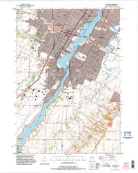 1992 De Pere1996 Print · USGSThe Fox River valley in the early nineties shows a landscape of institutional growth and deep-rooted community history. Researchers can find St Norbert College, the National Railroad Museum, and the historic path of Old Military Road near the De Pere Dam.
 - 1992 Map of Bellevue, 1996 Print
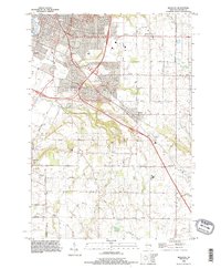 1992 Bellevue1996 Print · USGSBrown County experiences significant suburban growth during the nineties as residential developments expand into the rural landscapes of Allouez. Trace family history and land use through Bellevue Cemetery, the Landing Strip, and the prominent heights of Scray Hill.
End of results
Showing maps 1-2 of 2
Top cities near Allouez
- Green Bay historical maps
- De Pere historical maps
- Howard historical maps
- Kaukauna historical maps
- Bellevue historical maps
- Suamico historical maps
See more
Frequently asked questions
- What are the different types of historical maps available for Allouez?
- What is the oldest map of Allouez?
- Where can I purchase historical maps of Allouez for my home or office?
- Where can I download high-res historical maps of Allouez?
- Are there historical topographic maps available for Allouez?
- Is there historical aerial imagery available for Allouez?
- Where are historical maps of Allouez sourced from?