Old Maps of Askeaton, Holland for Metal Detecting
Plan your next treasure hunt with 6 historic maps of Askeaton. Find old homesites, ghost towns, trails, and gathering spots that may be lost to time — perfect for identifying promising metal detecting locations.
- Locate forgotten sites: Uncover places like long-lost settlements, abandoned rail lines, or gathering spots.
- Plan better hunts: Use map overlays combined with LiDAR or satellite views to narrow in on historically rich areas.
- Made for detectorists: Thousands of hobbyists use these maps to discover relics, coins, and hidden history.
Use these historic maps to boost your research and find new opportunities beneath the surface of Askeaton.
Askeaton, Holland maps
(6)- 1954 Map of De Pere, 1956 Print
 1954 De Pere1956 Print · USGSThe Fox River valley in the mid-1950s was a hub of industrial navigation and growing aviation between De Pere and Green Bay. Genealogists can trace family names through dozens of rural sites like St Patrick Cem, Gopher Hill, and the Michaelson Sch (Abandoned).2 unique versions available
 - 1955 Map of Green Bay, 1968 Print
 1955 Green Bay1968 Print · USGSCentral and Eastern Wisconsin are captured here in the mid-fifties, showing the industrial growth of the Fox Valley and Wisconsin River corridors. Genealogists and historians can trace rail lines like the Green Bay and Western through settlements like Weyauwega, Clintonville, and Pulaski.2 unique versions available
 - 1974 Map of Greenleaf, 1978 Print
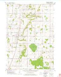 1974 Greenleaf1978 Print · USGSCentral Brown County in the mid-seventies reveals a landscape defined by the East River and the rural crossroads of Greenleaf. Genealogists and historians can trace old family roads, St Marys Sch, and the grounds of the Holland State Wildlife Area.
 - 1984 Map of Appleton, 1985 Print
 1984 Appleton1985 Print · USGSThe Fox River Valley in the mid-eighties shows a bustling corridor of industry and nature, from the shores of Lake Winnebago to the Oneida Indian Reservation. Trace local heritage through landmarks like Riverside Cem or explore the wetlands of Poygan Marsh State Wildlife Area.2 unique versions available
 - 1992 Map of Greenleaf, 1996 Print
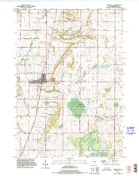 1992 Greenleaf1996 Print · USGSBrown County's rural townships are documented in the early 1990s as the agricultural landscape of Wrightstown and Holland evolved. Researchers can locate family sites such as St Johns Cem, the community of Askeaton, and the industrial footprint of the Quarry near Greenleaf.
 - 2022 Map of Greenleaf, 2022 Print
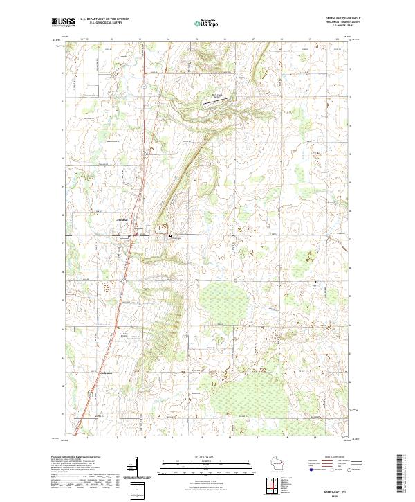 2022 Greenleaf2022 Print · USGSSouthern Brown County in the early 2020s remains a landscape of quiet rural settlements and historic thoroughfares. Genealogists and local historians can trace family-named routes and landmarks from Greenleaf down to Askeaton, including Fairview Cem and the Old Military Rd.
End of results
Showing maps 1-6 of 6
Top cities near Askeaton
- Green Bay historical maps
- De Pere historical maps
- Kaukauna historical maps
- Allouez historical maps
- Bellevue historical maps
- Little Chute historical maps
See more
Frequently asked questions
- What are the different types of historical maps available for Askeaton?
- What is the oldest map of Askeaton?
- Where can I purchase historical maps of Askeaton for my home or office?
- Where can I download high-res historical maps of Askeaton?
- Are there historical topographic maps available for Askeaton?
- Is there historical aerial imagery available for Askeaton?
- Where are historical maps of Askeaton sourced from?