1970s Maps of Modena, Wisconsin
Explore 4 historic maps of Modena from the 1970s. These maps offer a rare glimpse into what life looked like during the 1970s — showing old roads, neighborhoods, homes, and landmarks that have changed or disappeared over time.
Whether you're researching your family's past, planning a metal detecting trip, or studying how Modena's landscape evolved across the 1970s, these high-resolution maps are a powerful tool for exploring the history of this region.
- Focus on a specific era: All maps on this page are from the 1970s, giving you a focused view of this time period.
- See what’s changed: Compare century-old streets, trails, and buildings to today's modern landscape using overlays and satellite layers.
- Research with precision: Use these maps for genealogy, historical research, land use analysis, or educational projects.
- View, download, or print: Maps are fully viewable online in high resolution, and can be downloaded or printed for your own records.
Start exploring Modena's history through authentic maps from the 1970s. This is your window into the past.
Modena, WI maps
(4)- 1972 Map of Tarrant, 1975 Print
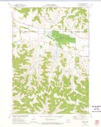 1972 Tarrant1975 Print · USGSBuffalo County in the early seventies is a landscape of deeply carved valleys and conservation land. Genealogists and local historians can locate rural landmarks like Sacred Heart Cem, Tiffany Sch, and the small settlement of Tarrant.
 - 1972 Map of Durand South, 1975 Print
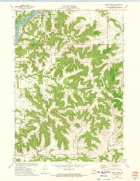 1972 Durand South1975 Print · USGSThe river and rail corridor of the Chippewa River meets the rugged bluff country of Buffalo County during the early 1970s. Researchers can trace the path of the Chicago Milwaukee St Paul and Pacific RR or locate family sites at St Mary Cem and North Branch Cem.2 unique versions available
 - 1974 Map of Modena, 1977 Print
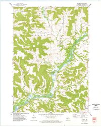 1974 Modena1977 Print · USGSThe Buffalo River valley and its many winding coulees define this mid-1970s survey of rural Buffalo County. Genealogists and researchers can trace family lands near Modena, Tell, and Praag, or locate landmarks like St Paul Ch and Modena Cem.
 - 1974 Map of Urne, 1977 Print
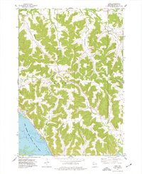 1974 Urne1977 Print · USGSBuffalo County's river bluffs and interior valleys are captured here in the mid-seventies, showing the intersection of rail transport and rural life. Researchers can locate family landmarks like Lyster Ch, Church Valley Cem, and the tracks of the Burlington Northern.
End of results
Showing maps 1-4 of 4
Top cities near Modena
- Mondovi historical maps
- Wabasha historical maps
- Red Cedar historical maps
- Durand historical maps
- Buffalo City historical maps
- Eau Galle historical maps
See more
Frequently asked questions
- What are the different types of historical maps available for Modena?
- What is the oldest map of Modena?
- Where can I purchase historical maps of Modena for my home or office?
- Where can I download high-res historical maps of Modena?
- Are there historical topographic maps available for Modena?
- Is there historical aerial imagery available for Modena?
- Where are historical maps of Modena sourced from?