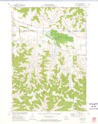
1972 Map of Tarrant
USGS Topo · Published 1975About this map
Big Swamp State Public Hunting Grounds dominates the central landscape of this early 1970s survey, marking a significant hydrologic feature where Bear Creek and Tiffany Creek converge. The terrain is defined by a dense network of coulees and valleys, such as Newton Valley and Brunner Coulee, which dictate the placement of small rural communities and farmsteads. The settlement of Tarrant sits at the junction of several drainage basins, while Owens occupies the southwestern portion of the sheet. Local social foundations are evidenced by the presence of the Tiffany Sch, St Paul Ch, and Sacred Heart Cem. The map illustrates the specialized land use of the Driftless Area, where narrow valley floors provide the primary space for agriculture and transport, separated by steep-walled ridges that remain primarily forested or utilized for public conservation.
Find a feature on this map
33 named features on this map. Tap any name to fly to it.
Don’t see what you’re looking for? This feature index may not catch every label — zoom into the map to look around manually.
Map Details
Editions of this 1972 Tarrant Map
This is the sole edition of this map. No revisions or reprints were ever made.
Other maps of this area

1929 · Durand
USGS Topo · 1:62,500

1932 · Gilmanton
USGS Topo · 1:62,500

1932 · Durand
USGS Topo · 1:62,500

1932 · Alma
USGS Topo · 1:62,500

1932 · Mondovi
USGS Topo · 1:62,500

1950 · Alma
USGS Topo · 1:62,500

1953 · Eau Claire
USGS Topo · 1:250,000

1958 · Eau Claire
USGS Topo · 1:250,000

1964 · Eau Claire
USGS Topo · 1:250,000
1972 · Meridean
USGS Topo · 1:24,000