1970s Maps of Brothertown, Wisconsin
Explore 4 historic maps of Brothertown from the 1970s. These maps offer a rare glimpse into what life looked like during the 1970s — showing old roads, neighborhoods, homes, and landmarks that have changed or disappeared over time.
Whether you're researching your family's past, planning a metal detecting trip, or studying how Brothertown's landscape evolved across the 1970s, these high-resolution maps are a powerful tool for exploring the history of this region.
- Focus on a specific era: All maps on this page are from the 1970s, giving you a focused view of this time period.
- See what’s changed: Compare century-old streets, trails, and buildings to today's modern landscape using overlays and satellite layers.
- Research with precision: Use these maps for genealogy, historical research, land use analysis, or educational projects.
- View, download, or print: Maps are fully viewable online in high resolution, and can be downloaded or printed for your own records.
Start exploring Brothertown's history through authentic maps from the 1970s. This is your window into the past.
Brothertown, WI maps
(4)- 1974 Map of Chilton, 1977 Print
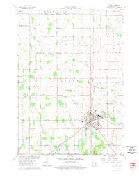 1974 Chilton1977 Print · USGSCalumet County in the mid-seventies remains a vital rail and agricultural hub centered on the city of Chilton. Genealogists and local historians can trace family-named roads like Ortlepp Road and Lau Road, or locate rural landmarks such as St Lukes Ch and Portland Cem.
 - 1974 Map of Marytown, 1977 Print
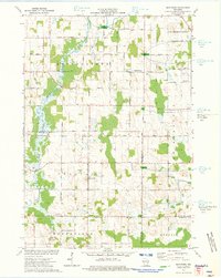 1974 Marytown1977 Print · USGSEastern Wisconsin dairy country is captured here in the mid-seventies at the meeting of Calumet, Fond du Lac, and Sheboygan counties. Genealogists can trace family farm locations near Marytown, Charlesburg, and the St Charles Cem.
 - 1974 Map of Stockbridge, 1978 Print
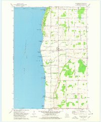 1974 Stockbridge1978 Print · USGSThe eastern shore of Lake Winnebago is captured in the mid-1970s, showing a landscape defined by treaty boundaries and lakefront life. Genealogists can trace family names at Pingel Cem or Dorn Cem, and locate the old Indian Cem near Stockbridge.
 - 1974 Map of Brothertown, 1978 Print
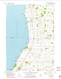 1974 Brothertown1978 Print · USGSThe eastern shores of Lake Winnebago come into focus during the mid-seventies, showing a landscape defined by historic county boundaries and shoreline developments. Genealogists and local researchers can trace sites like Union Cemetery, the crossroads at Jericho, and the lakeside community of Artesia Beach.
End of results
Showing maps 1-4 of 4
Top cities near Brothertown
- Fond du Lac historical maps
- Neenah historical maps
- Fox Crossing historical maps
- Menasha historical maps
- Harrison historical maps
- Taycheedah historical maps
See more
Top neighborhoods of Brothertown
- Charlesburg historical maps
- Jericho historical maps
- Maple Heights historical maps
- Brothertown Beach historical maps
- Elmwood Beach historical maps
- Gladwater Beach historical maps
See more
Frequently asked questions
- What are the different types of historical maps available for Brothertown?
- What is the oldest map of Brothertown?
- Where can I purchase historical maps of Brothertown for my home or office?
- Where can I download high-res historical maps of Brothertown?
- Are there historical topographic maps available for Brothertown?
- Is there historical aerial imagery available for Brothertown?
- Where are historical maps of Brothertown sourced from?