1940s Maps of Chippewa County, Wisconsin
Explore 6 historic maps of Chippewa County from the 1940s. These maps offer a rare glimpse into what life looked like during the 1940s — showing old roads, neighborhoods, homes, and landmarks that have changed or disappeared over time.
Whether you're researching your family's past, planning a metal detecting trip, or studying how Chippewa County's landscape evolved across the 1940s, these high-resolution maps are a powerful tool for exploring the history of this region.
- Focus on a specific era: All maps on this page are from the 1940s, giving you a focused view of this time period.
- See what’s changed: Compare century-old streets, trails, and buildings to today's modern landscape using overlays and satellite layers.
- Research with precision: Use these maps for genealogy, historical research, land use analysis, or educational projects.
- View, download, or print: Maps are fully viewable online in high resolution, and can be downloaded or printed for your own records.
Start exploring Chippewa County's history through authentic maps from the 1940s. This is your window into the past.
Chippewa County, WI maps
(6)- 1947 Map of Sheldon, 1967 Print
 1947 Sheldon1967 Print · USGSRusk and Taylor counties come into focus in the late 1940s, showing a landscape of river-valley settlements and timber management. Genealogists and historians can locate dozens of country schools and churches, from Sheldon to the Mt Nebo Cem and Hannibal.
 - 1948 Map of Weyerhauser, 1964 Print
 1948 Weyerhauser1964 Print · USGSRusk County at mid-century is a landscape of glacial lakes and tight-knit rural districts organized around the Soo Line railroad. Genealogists can locate long-lost rural institutions including Pleasant Hill Sch, the Indian Cem, and the historic townsite of Apollonia.
 - 1948 Map of Ladysmith, 1967 Print
 1948 Ladysmith1967 Print · USGSRusk County and the Flambeau River are captured here in the late 1940s as a thriving hub of rail, timber, and water power. Researchers can locate numerous vanished country schools like Grant Center Sch and trace early river control at the Port Arthur Dam and Thornapple Dam.
 - 1949 Map of Sheldon
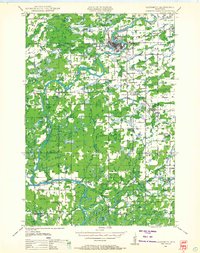
 1949 Sheldon1949 Print · USGSRusk and Taylor counties come into focus during the late 1940s, showing a landscape defined by small rail towns and scattered district schools. You can locate family-named landmarks like Baughman School or trace the early paths of the Jump River and Main Creek.
 - 1949 Map of Bloomer, 1966 Print
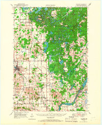 1949 Bloomer1966 Print · USGSThe dairy farms and lake country of northwestern Wisconsin are captured here in the late 1940s. Genealogists can trace rural family roots through numerous local schools and cemeteries, from Mile Corner Sch and Modern Sch to Tillinghast Cem and Rutledge Cem.2 unique versions available
 - 1949 Map of New Auburn, 1967 Print
 1949 New Auburn1967 Print · USGSWisconsin's rural dairy and timber heartland is meticulously documented here just after the war, showing the tight-knit settlement of western Chippewa County. Genealogists can trace family roots through numerous local landmarks like Fox Settlement, Lower Lutheran Ch, and New Auburn Cem.
End of results
Showing maps 1-6 of 6
Top cities of Chippewa County
- Chippewa Falls historical maps
- Lake Hallie historical maps
- Stanley historical maps
- Bloomer historical maps
- Eagle Point historical maps
- Anson historical maps
See more
Frequently asked questions
- What are the different types of historical maps available for Chippewa County?
- What is the oldest map of Chippewa County?
- Where can I purchase historical maps of Chippewa County for my home or office?
- Where can I download high-res historical maps of Chippewa County?
- Are there historical topographic maps available for Chippewa County?
- Is there historical aerial imagery available for Chippewa County?
- Where are historical maps of Chippewa County sourced from?