1950s Maps of Chippewa County, Wisconsin
Explore 13 historic maps of Chippewa County from the 1950s. These maps offer a rare glimpse into what life looked like during the 1950s — showing old roads, neighborhoods, homes, and landmarks that have changed or disappeared over time.
Whether you're researching your family's past, planning a metal detecting trip, or studying how Chippewa County's landscape evolved across the 1950s, these high-resolution maps are a powerful tool for exploring the history of this region.
- Focus on a specific era: All maps on this page are from the 1950s, giving you a focused view of this time period.
- See what’s changed: Compare century-old streets, trails, and buildings to today's modern landscape using overlays and satellite layers.
- Research with precision: Use these maps for genealogy, historical research, land use analysis, or educational projects.
- View, download, or print: Maps are fully viewable online in high resolution, and can be downloaded or printed for your own records.
Start exploring Chippewa County's history through authentic maps from the 1950s. This is your window into the past.
Chippewa County, WI maps
(13)- 1950 Map of Weyerhauser
 1950 Weyerhauser1950 Print · USGSRusk County at the dawn of the 1950s reveals a transition from timber-driven rail towns to a landscape of lakeside communities. Genealogists and historians can trace local landmarks like Indian Cem, the Stan Lookout Tower, and numerous rural schoolhouses including Amacoy Sch.
 - 1950 Map of Ladysmith
 1950 Ladysmith1950 Print · USGSMid-century Rusk County centers on the busy rail junction and riverfront of Ladysmith just as the regional flowages were being established. Researchers can locate dozens of rural schools and churches, including Meadow Brook Sch, St Francis Ch, and the Thornapple Dam.
 - 1951 Map of Bloomer
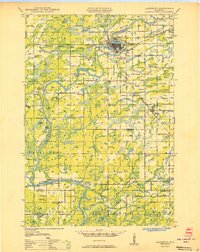
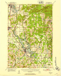
 1951 Bloomer1951 Print · USGSPost-war Chippewa County is seen here during a period of rural consolidation across its glaciated lake country. Local researchers can trace family roots through numerous country schools and cemeteries, including Tillinghast Cem, Emanuel Ch, and Larson Sch.2 unique versions available
 - 1951 Map of New Auburn
 1951 New Auburn1951 Print · USGSThe intersection of Barron, Dunn, and Chippewa counties comes into focus in the early 1950s, showing a landscape thick with local school districts and rural parishes. Genealogists can trace family footprints through dozens of named sites like Fox Settlement Sch, Dovre Ch, and the New Auburn Cem.
 - 1951 Map of Cornell, 1953 Print
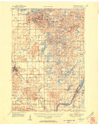
 1951 Cornell1953 Print · USGSCentral Chippewa County in the early fifties shows a landscape of river-driven industry and rural community life. Genealogists can trace family roots at Bohemia Cem or St Joseph Cem, and locate numerous schools like Firth Sch (Aband).
 - 1951 Map of Chetek, 1953 Print
 1951 Chetek1953 Print · USGSThe Chetek region in the early fifties shows a landscape of interconnected glacial lakes and growing rail towns. Trace the history of rural education and transport through local landmarks like Edgewood Sch and the CHICAGO AND NORTH WESTERN railroad.2 unique versions available
 - 1951 Map of Gilman, 1969 Print
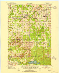
 1951 Gilman1969 Print · USGSTaylor and Clark counties are captured here in the early fifties, showing a rural landscape defined by the Yellow River and the Soo Line railroad. Genealogists can locate numerous landmarks including the Russian Ch, Meadowbrook Cem, and the Sunnyview Sch.
 - 1952 Map of Cadott, 1954 Print
 1952 Cadott1954 Print · USGSChippewa and Eau Claire counties were defined by a thriving network of small school districts and railroad towns in the early fifties. Genealogists can trace family roots through numerous sites like St Rose Cem, Bethlehem Ch, and Baker Sch.2 unique versions available
 - 1952 Map of Stanley, 1954 Print
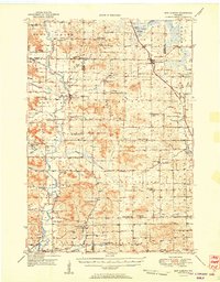
 1952 Stanley1954 Print · USGSStanley and Thorp anchor this central Wisconsin landscape in the early fifties as the rural schoolhouse system reaches its peak. Genealogists can locate family names at the Evergreen Cem or trace rural education at Busy Bee Sch and Sol Mohr Sch.
 - 1953 Map of Eau Claire, 1965 Print
 1953 Eau Claire1965 Print · USGSWest-central Wisconsin in the mid-fifties shows a landscape of river-valley industry and vast wildlife refuges during the transition from rails to modern highways. Genealogists and historians can trace the rail corridors of the Chicago and North Western or locate family-named landmarks like Decorah Mound and Chippewa Island.4 unique versions available
 - 1953 Map of Rice Lake, 1967 Print
 1953 Rice Lake1967 Print · USGSNorthwest Wisconsin during the mid-fifties reveals a landscape defined by timber, rail, and water. Genealogists and historians can trace the development of river towns like Ladysmith and Rice Lake along the Soo Line and Chicago and North Western railroads.2 unique versions available
 - 1958 Map of Eau Claire
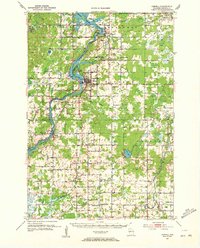
 1958 Eau Claire1958 Print · USGSWestern Wisconsin in the late fifties shows a landscape of growing regional hubs and massive wildlife refuges. Trace the rail lines of the Chicago and North Western between Eau Claire and Marshfield, or explore the terrain around Iron Mound and Lake Wissota.
 - 1959 Map of Rice Lake
 1959 Rice Lake1959 Print · USGSNorthwest Wisconsin in the late fifties was a land of expanding road networks and deep-seated timber history. Genealogists and historians can trace rail lines like the Soo Line RR and Chicago St Paul Minneapolis and Omaha Ry as they link settlements from Spooner to Medford.
End of results
Showing maps 1-13 of 13
Top cities of Chippewa County
- Chippewa Falls historical maps
- Lake Hallie historical maps
- Stanley historical maps
- Bloomer historical maps
- Eagle Point historical maps
- Anson historical maps
See more
Frequently asked questions
- What are the different types of historical maps available for Chippewa County?
- What is the oldest map of Chippewa County?
- Where can I purchase historical maps of Chippewa County for my home or office?
- Where can I download high-res historical maps of Chippewa County?
- Are there historical topographic maps available for Chippewa County?
- Is there historical aerial imagery available for Chippewa County?
- Where are historical maps of Chippewa County sourced from?