1970s Maps of Auburn, Wisconsin
Explore 4 historic maps of Auburn from the 1970s. These maps offer a rare glimpse into what life looked like during the 1970s — showing old roads, neighborhoods, homes, and landmarks that have changed or disappeared over time.
Whether you're researching your family's past, planning a metal detecting trip, or studying how Auburn's landscape evolved across the 1970s, these high-resolution maps are a powerful tool for exploring the history of this region.
- Focus on a specific era: All maps on this page are from the 1970s, giving you a focused view of this time period.
- See what’s changed: Compare century-old streets, trails, and buildings to today's modern landscape using overlays and satellite layers.
- Research with precision: Use these maps for genealogy, historical research, land use analysis, or educational projects.
- View, download, or print: Maps are fully viewable online in high resolution, and can be downloaded or printed for your own records.
Start exploring Auburn's history through authentic maps from the 1970s. This is your window into the past.
Auburn, WI maps
(4)- 1975 Map of Colfax North, 1978 Print
 1975 Colfax North1978 Print · USGSDunn County at the mid-point of the 1970s shows a landscape of river-bottom farms and quiet rural crossroads. Genealogists can trace family footprints through numerous sites like St Johns Ch, Evergreen Cem, and the village streets of Colfax.
 - 1975 Map of New Auburn, 1978 Print
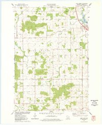
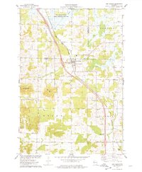 1975 New Auburn1978 Print · USGSWestern Wisconsin life in the mid-seventies centers on the village of New Auburn and its position along the Chicago and North Western railroad. Researchers can locate family sites at the New Auburn Cem, trace Duncan Creek, or explore the wooded Old Maids Bluff.
 - 1975 Map of Sand Creek, 1978 Print
 1975 Sand Creek1978 Print · USGSNorthwest Wisconsin in the 1970s shows a landscape defined by the winding Red Cedar River and the rural communities of Dunn and Barron Counties. Genealogists and local historians can trace family locations near Sand Creek, Cruikshank, and several early burial grounds including Zion Cem and Springbrook Cem.
 - 1975 Map of Como Creek, 1978 Print
 1975 Como Creek1978 Print · USGSChippewa County agriculture and township boundaries are captured here in the mid-1970s. Researchers can trace family roots at Cooks Valley Cem, St Johns Ch, and the settlement of Albert along the banks of Como Lake.
End of results
Showing maps 1-4 of 4
Top cities near Auburn
- Chippewa Falls historical maps
- Bloomer historical maps
- Eagle Point historical maps
- Chetek historical maps
- Tainter historical maps
- Red Cedar historical maps
See more
Frequently asked questions
- What are the different types of historical maps available for Auburn?
- What is the oldest map of Auburn?
- Where can I purchase historical maps of Auburn for my home or office?
- Where can I download high-res historical maps of Auburn?
- Are there historical topographic maps available for Auburn?
- Is there historical aerial imagery available for Auburn?
- Where are historical maps of Auburn sourced from?