1970s Maps of Lewiston, Wisconsin
Explore 4 historic maps of Lewiston from the 1970s. These maps offer a rare glimpse into what life looked like during the 1970s — showing old roads, neighborhoods, homes, and landmarks that have changed or disappeared over time.
Whether you're researching your family's past, planning a metal detecting trip, or studying how Lewiston's landscape evolved across the 1970s, these high-resolution maps are a powerful tool for exploring the history of this region.
- Focus on a specific era: All maps on this page are from the 1970s, giving you a focused view of this time period.
- See what’s changed: Compare century-old streets, trails, and buildings to today's modern landscape using overlays and satellite layers.
- Research with precision: Use these maps for genealogy, historical research, land use analysis, or educational projects.
- View, download, or print: Maps are fully viewable online in high resolution, and can be downloaded or printed for your own records.
Start exploring Lewiston's history through authentic maps from the 1970s. This is your window into the past.
Lewiston, WI maps
(4)- 1975 Map of Pine Island, 1978 Print
 1975 Pine Island1978 Print · USGSThe Wisconsin River and its intricate sloughs define this rural landscape in the mid-seventies, just as the local wildlife areas were becoming established. Researchers can find old community anchors like Lewiston Sch, the Welsh Cem, and the path of the Chicago Milwaukee St Paul and Pacific railroad.
 - 1975 Map of Lewiston, 1978 Print
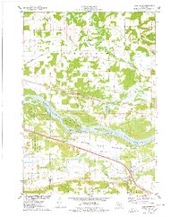
 1975 Lewiston1978 Print · USGSThe Wisconsin River valley in the mid-1970s shows a landscape of small crossroads settlements and heavy rail infrastructure. Genealogists and local historians can trace family locations near Pecks Corners, the Fairfield Center Sch, and Hillcrest Cem.
 - 1975 Map of Big Spring, 1978 Print
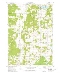 1975 Big Spring1978 Print · USGSSettled between Adams and Columbia counties in the mid-1970s, this area shows a mix of rural town halls and lakefront recreation. Genealogists can trace local roots at Davis Corners Ch or explore the early lakeside developments of Jordan Lake and Big Spring.
 - 1975 Map of Briggsville, 1978 Print
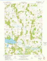 1975 Briggsville1978 Print · USGSBriggsville and the surrounding lake country are captured in the mid-seventies just as the region's recreational and agricultural identities converged. Genealogists and historians can locate the Douglas Ch, Greenwood Cem, and a local Cheese Factory near the shores of Mason Lake.
End of results
Showing maps 1-4 of 4
Top cities near Lewiston
- Baraboo historical maps
- Portage historical maps
- Lake Delton historical maps
- Wisconsin Dells historical maps
- Poynette historical maps
- Dekorra historical maps
See more
Frequently asked questions
- What are the different types of historical maps available for Lewiston?
- What is the oldest map of Lewiston?
- Where can I purchase historical maps of Lewiston for my home or office?
- Where can I download high-res historical maps of Lewiston?
- Are there historical topographic maps available for Lewiston?
- Is there historical aerial imagery available for Lewiston?
- Where are historical maps of Lewiston sourced from?