1980s Maps of Sunset Beach, Beaver Dam
Explore 2 historic maps of Sunset Beach from the 1980s. These maps offer a rare glimpse into what life looked like during the 1980s — showing old roads, neighborhoods, homes, and landmarks that have changed or disappeared over time.
Whether you're researching your family's past, planning a metal detecting trip, or studying how Sunset Beach's landscape evolved across the 1980s, these high-resolution maps are a powerful tool for exploring the history of this region.
- Focus on a specific era: All maps on this page are from the 1980s, giving you a focused view of this time period.
- See what’s changed: Compare century-old streets, trails, and buildings to today's modern landscape using overlays and satellite layers.
- Research with precision: Use these maps for genealogy, historical research, land use analysis, or educational projects.
- View, download, or print: Maps are fully viewable online in high resolution, and can be downloaded or printed for your own records.
Start exploring Sunset Beach's history through authentic maps from the 1980s. This is your window into the past.
Sunset Beach, Beaver Dam maps
(2)- 1980 Map of Fond Du Lac
 1980 Fond Du Lac1980 Print · USGSThe Fox River Valley and Horicon Marsh meet here during the late twentieth century, showing a transition from lakeside industry to glacial conservation. Genealogists can locate family sites at Estabrook Cem or trace the rail lines through Ripon and Waupun.
 - 1980 Map of Buckhorn Corner, 1981 Print
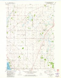 1980 Buckhorn Corner1981 Print · USGSDodge County dairy country is captured here during the 1980s, showcasing a landscape of family farms and wetland conservation. Genealogists can locate family sites near Trenton Center Cem, the Trenton Sch, and the St John Ch.
End of results
Showing maps 1-2 of 2
Top cities near Sunset Beach
- Beaver Dam historical maps
- Columbus historical maps
- Horicon historical maps
- Waupun historical maps
- Juneau historical maps
- Lebanon historical maps
See more
Frequently asked questions
- What are the different types of historical maps available for Sunset Beach?
- What is the oldest map of Sunset Beach?
- Where can I purchase historical maps of Sunset Beach for my home or office?
- Where can I download high-res historical maps of Sunset Beach?
- Are there historical topographic maps available for Sunset Beach?
- Is there historical aerial imagery available for Sunset Beach?
- Where are historical maps of Sunset Beach sourced from?