Old Maps of Sunset Beach, Beaver Dam for Metal Detecting
Plan your next treasure hunt with 6 historic maps of Sunset Beach. Find old homesites, ghost towns, trails, and gathering spots that may be lost to time — perfect for identifying promising metal detecting locations.
- Locate forgotten sites: Uncover places like long-lost settlements, abandoned rail lines, or gathering spots.
- Plan better hunts: Use map overlays combined with LiDAR or satellite views to narrow in on historically rich areas.
- Made for detectorists: Thousands of hobbyists use these maps to discover relics, coins, and hidden history.
Use these historic maps to boost your research and find new opportunities beneath the surface of Sunset Beach.
Sunset Beach, Beaver Dam maps
(6)- 1955 Map of Fox Lake, 1957 Print
 1955 Fox Lake1957 Print · USGSIn the mid-1950s, the Dodge and Green Lake County borderlands were defined by a high density of one-room schoolhouses and rail-dependent towns. Trace family roots at Tichora Cem or follow the old Milwaukee Road tracks through Markesan and Fox Lake Junction.
 - 1957 Map of Madison, 1967 Print
 1957 Madison1967 Print · USGSSouth-central Wisconsin in the mid-fifties reveals a landscape of industrial hubs and glacial lakes linked by a dense rail and highway network. Genealogists and historians can trace the development of lakeside communities and find notable sites like Badger Ordnance Works and the Horicon National Wildlife Refuge.3 unique versions available
 - 1960 Map of Madison
 1960 Madison1960 Print · USGSCentral and Southern Wisconsin are captured in the late fifties, showing the region as its rail-and-river network matured. Trace the paths of the Soo Line RR or locate family roots near Lake Mendota and Horicon National Wildlife Refuge.2 unique versions available
 - 1980 Map of Fond Du Lac
 1980 Fond Du Lac1980 Print · USGSThe Fox River Valley and Horicon Marsh meet here during the late twentieth century, showing a transition from lakeside industry to glacial conservation. Genealogists can locate family sites at Estabrook Cem or trace the rail lines through Ripon and Waupun.
 - 1980 Map of Buckhorn Corner, 1981 Print
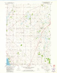 1980 Buckhorn Corner1981 Print · USGSDodge County dairy country is captured here during the 1980s, showcasing a landscape of family farms and wetland conservation. Genealogists can locate family sites near Trenton Center Cem, the Trenton Sch, and the St John Ch.
 - 2022 Map of Buckhorn Corner, 2022 Print
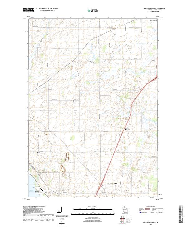 2022 Buckhorn Corner2022 Print · USGSThe rural corridor between Waupun and Beaver Dam is captured here in the early twenty-first century, showing a landscape of scattered family farms and quiet waterways. Researchers can trace local heritage at Trenton Cem, Annunciation Cem, or follow the shoreline of Beaver Dam Lake.
End of results
Showing maps 1-6 of 6
Top cities near Sunset Beach
- Beaver Dam historical maps
- Columbus historical maps
- Horicon historical maps
- Waupun historical maps
- Juneau historical maps
- Lebanon historical maps
See more
Frequently asked questions
- What are the different types of historical maps available for Sunset Beach?
- What is the oldest map of Sunset Beach?
- Where can I purchase historical maps of Sunset Beach for my home or office?
- Where can I download high-res historical maps of Sunset Beach?
- Are there historical topographic maps available for Sunset Beach?
- Is there historical aerial imagery available for Sunset Beach?
- Where are historical maps of Sunset Beach sourced from?