Old Maps of Taycheedah, Wisconsin for Metal Detecting
Plan your next treasure hunt with 14 historic maps of Taycheedah. Find old homesites, ghost towns, trails, and gathering spots that may be lost to time — perfect for identifying promising metal detecting locations.
- Locate forgotten sites: Uncover places like long-lost settlements, abandoned rail lines, or gathering spots.
- Plan better hunts: Use map overlays combined with LiDAR or satellite views to narrow in on historically rich areas.
- Made for detectorists: Thousands of hobbyists use these maps to discover relics, coins, and hidden history.
Use these historic maps to boost your research and find new opportunities beneath the surface of Taycheedah.
Taycheedah, WI maps
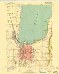
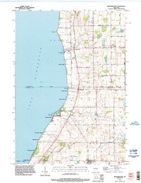
(14)- 1910 Map of Fond du Lac
 1910 Fond du Lac1910 Print · USGSThe southern shores of Lake Winnebago appear in high detail during this era of rapid railroad expansion and agricultural growth. Genealogists and local historians can trace early property locations near Rienzi Cemetery, Brothertown, and the busy rail yards of North Fond du Lac.2 unique versions available
 - 1955 Map of Fond Du Lac, 1957 Print
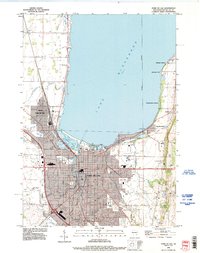
 1955 Fond Du Lac1957 Print · USGSMid-century Fond du Lac County unfolds along the eastern shore of Lake Winnebago, where bustling city streets meet a coastline dotted with summer beaches and seaplane bases. Genealogists can trace family roots through Rienzi Cem, local parish schools like St Pauls Sch, and rural hamlets such as Taycheedah and Pipe.2 unique versions available
 - 1955 Map of Fond Du Lac, 1966 Print
 1955 Fond Du Lac1966 Print · USGSFond du Lac at the edge of the lake in the mid-fifties shows a bustling hub of rail, aviation, and education. Trace the development of Marian College, the sprawling rail yards in North Fond du Lac, and lakeside spots like Lakeside Park.2 unique versions available
 - 1957 Map of Madison, 1967 Print
 1957 Madison1967 Print · USGSSouth-central Wisconsin in the mid-fifties reveals a landscape of industrial hubs and glacial lakes linked by a dense rail and highway network. Genealogists and historians can trace the development of lakeside communities and find notable sites like Badger Ordnance Works and the Horicon National Wildlife Refuge.3 unique versions available
 - 1960 Map of Madison
 1960 Madison1960 Print · USGSCentral and Southern Wisconsin are captured in the late fifties, showing the region as its rail-and-river network matured. Trace the paths of the Soo Line RR or locate family roots near Lake Mendota and Horicon National Wildlife Refuge.2 unique versions available
 - 1974 Map of St. Peter, 1978 Print
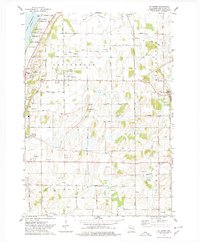 1974 St. Peter1978 Print · USGSThe eastern shore of Lake Winnebago meets the rural hills of Fond du Lac County in the mid-1970s. Genealogists and local historians can trace the foundations of St Peter, locate the Taycheedah Cem, and follow the Old Railroad Grade through Silica.
 - 1974 Map of Brothertown, 1978 Print
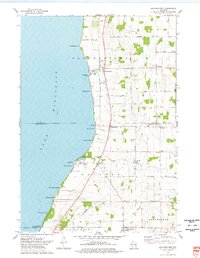 1974 Brothertown1978 Print · USGSThe eastern shores of Lake Winnebago come into focus during the mid-seventies, showing a landscape defined by historic county boundaries and shoreline developments. Genealogists and local researchers can trace sites like Union Cemetery, the crossroads at Jericho, and the lakeside community of Artesia Beach.
 - 1980 Map of Fond Du Lac
 1980 Fond Du Lac1980 Print · USGSThe Fox River Valley and Horicon Marsh meet here during the late twentieth century, showing a transition from lakeside industry to glacial conservation. Genealogists can locate family sites at Estabrook Cem or trace the rail lines through Ripon and Waupun.
 - 1992 Map of Fond Du Lac, 1996 Print
 1992 Fond Du Lac1996 Print · USGSThe southern shores of Lake Winnebago are seen here in the early 1990s as the city of Fond du Lac expands eastward. Researchers can trace local landmarks like Rienzi Cemetery, the Old Railroad Grade, and the shoreline settlements of Taycheedah and Peebles.
 - 1992 Map of Brothertown, 1996 Print
 1992 Brothertown1996 Print · USGSThe eastern shores of Lake Winnebago come into focus in the early nineties, revealing a landscape of lakeside hamlets and traditional farmsteads. Researchers can trace family roots at Union Cemetery or explore the development of coastal communities like Artesia Beach and Brothertown.
 - 1992 Map of Saint Peter, 1996 Print
 1992 Saint Peter1996 Print · USGSSettlements along the eastern shore of Lake Winnebago appear in the early nineties, from the beaches near Peebles to the rural uplands. Trace the OLD RAILROAD GRADE and locate family landmarks like St Peters church or Forest Cemetery.
 - 2022 Map of Saint Peter, 2022 Print
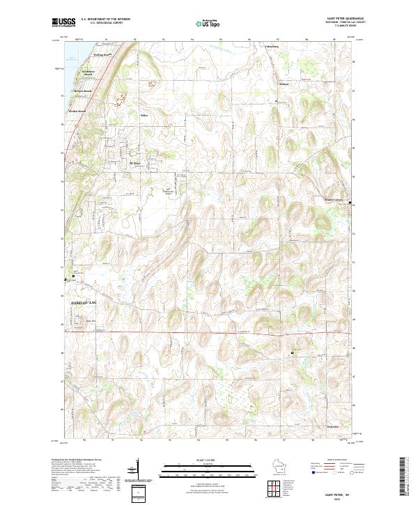 2022 Saint Peter2022 Print · USGSThe eastern shores of Lake Winnebago and the rural uplands of Fond du Lac County are captured here in the early twenty-first century. Researchers can locate family sites near Mount Calvary or trace the development of lakeside communities like Bergen Beach and Linden Beach.
 - 2022 Map of Fond du Lac, 2022 Print
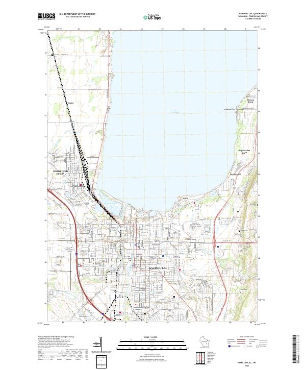 2022 Fond du Lac2022 Print · USGSThe southern shore of Lake Winnebago comes into focus in this recent survey of the region's urban and recreational landscape. Genealogists and historians can trace cemetery locations like Rienzi Cem and explore the shoreline communities of Minawa Beach and Taycheedah.
 - 2022 Map of Brothertown, 2022 Print
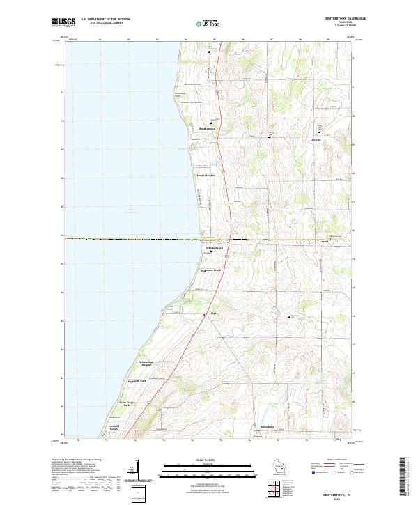 2022 Brothertown2022 Print · USGSThe eastern shore of Lake Winnebago comes into focus here during the early 2020s, showing a blend of lakeside communities and rural heritage. Genealogists and local historians can trace family roots through numerous sites like the Dick Family Cem, Holy Trinity Cem, and Union Cem.
End of results
Showing maps 1-14 of 14
Top cities near Taycheedah
- Oshkosh historical maps
- Fond du Lac historical maps
- North Fond du Lac historical maps
- Chilton historical maps
- New Holstein historical maps
- Greenbush historical maps
See more
Top neighborhoods of Taycheedah
- Minawa Beach historical maps
- Bergen Beach historical maps
- Peebles historical maps
- Welling Beach historical maps
- Gladstone Beach historical maps
- Linden Beach historical maps
See more
Frequently asked questions
- What are the different types of historical maps available for Taycheedah?
- What is the oldest map of Taycheedah?
- Where can I purchase historical maps of Taycheedah for my home or office?
- Where can I download high-res historical maps of Taycheedah?
- Are there historical topographic maps available for Taycheedah?
- Is there historical aerial imagery available for Taycheedah?
- Where are historical maps of Taycheedah sourced from?