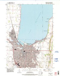
1992 Map of Fond Du Lac
USGS Topo · Published 1996About this map
Lake Winnebago dominates the northern half of this landscape, its southern shoreline defining the industrial and residential heart of Fond du Lac. The city's geography is shaped by the confluence of the West Branch and East Branch rivers, which flow through the center towards the Marsh at Lakeside Park. Education and public infrastructure are prominent features, with institutions like Marian College and the University of Wisconsin Center Fond du Lac established near the city's eastern edge.
Find a feature on this map
46 named features on this map. Tap any name to fly to it.
Don’t see what you’re looking for? This feature index may not catch every label — zoom into the map to look around manually.
Map Details
Editions of this 1992 Fond Du Lac Map
This is the sole edition of this map. No revisions or reprints were ever made.
Other maps of this area

1910 · Fond du Lac
USGS Topo · 1:62,500

1955 · Waupun
USGS Topo · 1:62,500

1955 · Campbellsport
USGS Topo · 1:62,500

1955 · Fond Du Lac
USGS Topo · 1:62,500

1955 · Fond Du Lac
USGS Topo · 1:24,000

1956 · Rosendale
USGS Topo · 1:62,500

1957 · Madison
USGS Topo · 1:250,000

1960 · Madison
USGS Topo · 1:250,000
1974 · St. Peter
USGS Topo · 1:24,000
1974 · Fahrney Point
USGS Topo · 1:24,000