1970s Maps of Oma, Wisconsin
Explore 4 historic maps of Oma from the 1970s. These maps offer a rare glimpse into what life looked like during the 1970s — showing old roads, neighborhoods, homes, and landmarks that have changed or disappeared over time.
Whether you're researching your family's past, planning a metal detecting trip, or studying how Oma's landscape evolved across the 1970s, these high-resolution maps are a powerful tool for exploring the history of this region.
- Focus on a specific era: All maps on this page are from the 1970s, giving you a focused view of this time period.
- See what’s changed: Compare century-old streets, trails, and buildings to today's modern landscape using overlays and satellite layers.
- Research with precision: Use these maps for genealogy, historical research, land use analysis, or educational projects.
- View, download, or print: Maps are fully viewable online in high resolution, and can be downloaded or printed for your own records.
Start exploring Oma's history through authentic maps from the 1970s. This is your window into the past.
Oma, WI maps
(4)- 1973 Map of Lake of The Falls, 1976 Print
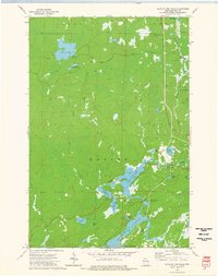 1973 Lake of The Falls1976 Print · USGSIron County's lake country in the early seventies shows a landscape shaped by water and the timber-era rail network. Researchers can trace the Chicago and North Western line through Carter or locate the Winter Trail near Moose Lake.
 - 1973 Map of Mercer, 1976 Print
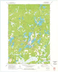 1973 Mercer1976 Print · USGSNorthern Wisconsin's lake country is captured here during the 1970s, centered on the rail-side settlement of Mercer. Genealogists and local historians can trace the Chicago and North Western line, Mercer Cem, and the Lookout Tower near the Turtle River.2 unique versions available
 - 1973 Map of Lake Evelyn, 1976 Print
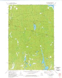 1973 Lake Evelyn1976 Print · USGSThe Michigan-Wisconsin borderlands in the early 1970s reveal a landscape shaped by the logging industry and conservation efforts. Researchers can trace defunct timber routes along several Old Railroad Grades or locate family landmarks like the Pine Lake Lookout Tower and Lake Evelyn.
 - 1973 Map of Pine Lake, 1977 Print
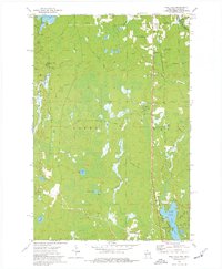 1973 Pine Lake1977 Print · USGSIron County, Wisconsin, in the 1970s was a landscape of dense woods, industrial rail, and quiet lakefront settlements. Genealogists and historians can trace the paths of the Chicago and North Western and the Old Railroad Grade near Sandrock and Oma.
End of results
Showing maps 1-4 of 4
Top cities near Oma
- Ironwood historical maps
- Wakefield historical maps
- Bessemer historical maps
- Mercer historical maps
- Hurley historical maps
- Montreal historical maps
See more
Top neighborhoods of Oma
Frequently asked questions
- What are the different types of historical maps available for Oma?
- What is the oldest map of Oma?
- Where can I purchase historical maps of Oma for my home or office?
- Where can I download high-res historical maps of Oma?
- Are there historical topographic maps available for Oma?
- Is there historical aerial imagery available for Oma?
- Where are historical maps of Oma sourced from?