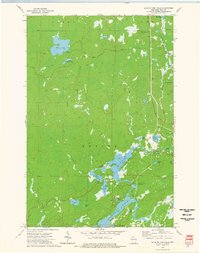
1973 Map of Lake of The Falls
USGS Topo · Published 1976About this map
Lake of the Falls serves as the centerpiece of this northern Wisconsin landscape, where the Turtle River flows through a series of interconnected basins including First Black Lake, Second Black Lake, and Third Black Lake. The 1970s terrain is defined by its complex hydrography and the expansive reach of the Turtle-Flambeau Flowage to the south. Transportation history is etched into the woodland, visible in the Chicago and North Western rail line and an Old RR Grade passing through the small settlement of Carter. Further north, Moose Lake and Little Moose Lake dominate the higher ground, while the presence of a Winter Trail and several boat ramps suggests a region deeply tied to seasonal navigation and outdoor recreation. The map also captures local landmarks like Lake of the Falls County Park and the distinctively named Lac de Beaumont, documenting the area's established recreational and residential patterns.
Find a feature on this map
35 named features on this map. Tap any name to fly to it.
Don’t see what you’re looking for? This feature index may not catch every label — zoom into the map to look around manually.
Map Details
Editions of this 1973 Lake of The Falls Map
This is the sole edition of this map. No revisions or reprints were ever made.
Other maps of this area

1940 · Mercer
USGS Topo · 1:48,000

1940 · Butternut
USGS Topo · 1:48,000

1940 · Upson
USGS Topo · 1:48,000

1943 · Upson
USGS Topo · 1:48,000

1943 · Ironwood
USGS Topo · 1:48,000

1945 · Mercer
USGS Topo · 1:48,000

1947 · Butternut
USGS Topo · 1:48,000

1947 · Mercer
USGS Topo · 1:48,000

1950 · Butternut
USGS Topo · 1:48,000

1953 · Ashland
USGS Topo · 1:250,000