1990s Maps of Campbell, Wisconsin
Explore 5 historic maps of Campbell from the 1990s. These maps offer a rare glimpse into what life looked like during the 1990s — showing old roads, neighborhoods, homes, and landmarks that have changed or disappeared over time.
Whether you're researching your family's past, planning a metal detecting trip, or studying how Campbell's landscape evolved across the 1990s, these high-resolution maps are a powerful tool for exploring the history of this region.
- Focus on a specific era: All maps on this page are from the 1990s, giving you a focused view of this time period.
- See what’s changed: Compare century-old streets, trails, and buildings to today's modern landscape using overlays and satellite layers.
- Research with precision: Use these maps for genealogy, historical research, land use analysis, or educational projects.
- View, download, or print: Maps are fully viewable online in high resolution, and can be downloaded or printed for your own records.
Start exploring Campbell's history through authentic maps from the 1990s. This is your window into the past.
Campbell, WI maps
(5)- 1990 Map of La Crosse, 1991 Print
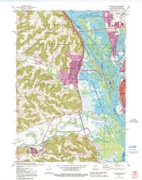
 1990 La Crosse1991 Print · USGSThe tri-state river valley at the end of the twentieth century shows a landscape defined by the Mississippi River and heavy rail. Trace the paths of the Soo Line and Burlington Northern through river towns like Brownsville and La Crescent.
 - 1991 Map of La Crescent, 1995 Print
 1991 La Crescent1995 Print · USGSThe Mississippi River valley in the early 1990s reveals a intricate landscape of island settlements and wildlife refuges between Minnesota and Wisconsin. You can trace old railroad lines like the Soo Line and locate historic sites such as Crucifixion Cem and Summit Sch.
 - 1993 Map of Onalaska
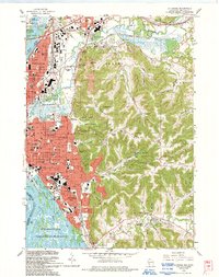
 1993 Onalaska1993 Print · USGSThe Coulee Region in the early nineties reveals a landscape where the growing city of Onalaska meets the waters of the Mississippi. Local historians can trace family-named landmarks like Jostad Coulee or Kinney Coulee and locate the Halfway Creek Cem.
 - 1993 Map of La Crosse
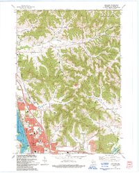
 1993 La Crosse1993 Print · USGSLa Crosse at the turn of the 1990s shows a bustling river city caught between the bluffs and the Mississippi. Researchers can trace local genealogy at Oak Grove Cemetery or locate neighborhood landmarks like St Francis Hospital and Viterbo College.
 - 1998 Map of La Crosse, 2001 Print
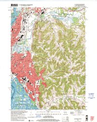 1998 La Crosse2001 Print · USGSLa Crosse at the close of the twentieth century remains a vibrant river city bounded by the Mississippi and its dramatic eastern bluffs. Researchers can trace family history through sites like Oak Grove Cemetery, the neighborhood surrounding Logan High Sch, and the ridge settlement of St Joseph.
End of results
Showing maps 1-5 of 5
Top cities near Campbell
- La Crosse historical maps
- Onalaska historical maps
- Holmen historical maps
- West Salem historical maps
- La Crescent historical maps
- Shelby historical maps
See more
Top neighborhoods of Campbell
Frequently asked questions
- What are the different types of historical maps available for Campbell?
- What is the oldest map of Campbell?
- Where can I purchase historical maps of Campbell for my home or office?
- Where can I download high-res historical maps of Campbell?
- Are there historical topographic maps available for Campbell?
- Is there historical aerial imagery available for Campbell?
- Where are historical maps of Campbell sourced from?