1970s Maps of Neva, Wisconsin
Explore 4 historic maps of Neva from the 1970s. These maps offer a rare glimpse into what life looked like during the 1970s — showing old roads, neighborhoods, homes, and landmarks that have changed or disappeared over time.
Whether you're researching your family's past, planning a metal detecting trip, or studying how Neva's landscape evolved across the 1970s, these high-resolution maps are a powerful tool for exploring the history of this region.
- Focus on a specific era: All maps on this page are from the 1970s, giving you a focused view of this time period.
- See what’s changed: Compare century-old streets, trails, and buildings to today's modern landscape using overlays and satellite layers.
- Research with precision: Use these maps for genealogy, historical research, land use analysis, or educational projects.
- View, download, or print: Maps are fully viewable online in high resolution, and can be downloaded or printed for your own records.
Start exploring Neva's history through authentic maps from the 1970s. This is your window into the past.
Neva, WI maps
(4)- 1973 Map of Antigo, 1976 Print
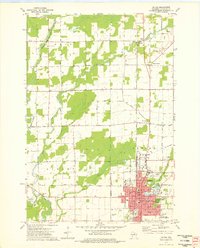 1973 Antigo1976 Print · USGSAntigo and the surrounding Langlade County countryside are captured in the early 1970s, as the city expanded around its river branches and rail corridors. Researchers can find numerous parochial schools and cemeteries, including St Hyacinths Sch and Bohemian Cem, alongside small rural hubs like Deerbrook.2 unique versions available
 - 1973 Map of Bryant, 1976 Print
 1973 Bryant1976 Print · USGSLanglade County's agricultural and forest lands are captured in the early seventies, showing a landscape defined by its rural townships and timber history. Genealogists and researchers can trace local landmarks like Bent Cem, Spring Valley Sch, and the Old Railroad Grade.
 - 1973 Map of Pearson, 1977 Print
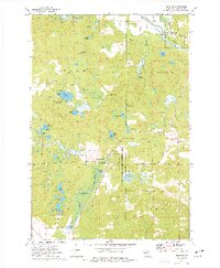 1973 Pearson1977 Print · USGSLanglade County in the early seventies shows a landscape defined by glacial lakes and the timber-era transition to conservation. Researchers can trace the Old Railroad Grade near Pearson or locate landmarks like the Pence Lake Lookout Tower and Crystal Spring Fish Hatchery.
 - 1973 Map of Kempster, 1977 Print
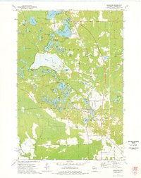 1973 Kempster1977 Print · USGSLanglade County's lake country in the early seventies shows a transition from rail-dependent industry to Northwoods recreation. Genealogists and researchers can trace the Chicago and North Western line through Kempster and find landmarks like Bogus Swamp or the Bass Lake Country Club.
End of results
Showing maps 1-4 of 4
Top cities near Neva
- Antigo historical maps
- Elcho historical maps
- Nashville historical maps
- Polar historical maps
- Langlade historical maps
- Enterprise historical maps
See more
Top neighborhoods of Neva
Frequently asked questions
- What are the different types of historical maps available for Neva?
- What is the oldest map of Neva?
- Where can I purchase historical maps of Neva for my home or office?
- Where can I download high-res historical maps of Neva?
- Are there historical topographic maps available for Neva?
- Is there historical aerial imagery available for Neva?
- Where are historical maps of Neva sourced from?