1980s Maps of Cassel, Wisconsin
Explore 5 historic maps of Cassel from the 1980s. These maps offer a rare glimpse into what life looked like during the 1980s — showing old roads, neighborhoods, homes, and landmarks that have changed or disappeared over time.
Whether you're researching your family's past, planning a metal detecting trip, or studying how Cassel's landscape evolved across the 1980s, these high-resolution maps are a powerful tool for exploring the history of this region.
- Focus on a specific era: All maps on this page are from the 1980s, giving you a focused view of this time period.
- See what’s changed: Compare century-old streets, trails, and buildings to today's modern landscape using overlays and satellite layers.
- Research with precision: Use these maps for genealogy, historical research, land use analysis, or educational projects.
- View, download, or print: Maps are fully viewable online in high resolution, and can be downloaded or printed for your own records.
Start exploring Cassel's history through authentic maps from the 1980s. This is your window into the past.
Cassel, WI maps
(5)- 1981 Map of Edgar, 1982 Print
 1981 Edgar1982 Print · USGSMarathon County in the early eighties shows a transition from rail-centered village life to modern infrastructure. Genealogists can locate family burial sites at Baesemann Cem or Holy Trinity Cem and trace the winding Big Rib River.
 - 1981 Map of Marathon SW, 1982 Print
 1981 Marathon SW1982 Print · USGSMarathon County in the early eighties centers on the expansive waters of the Big Eau Pleine Reservoir and the rural townships of Wien and Cassel. Researchers can trace old property lines and rural landmarks like Rocky Run, a localized Quarry, and the C & N W railroad line.
 - 1981 Map of Halder, 1982 Print
 1981 Halder1982 Print · USGSMarathon County’s rural landscape is captured here in the early eighties, defined by the expansion of the Big Eau Pleine Reservoir. Genealogists and local historians can locate St Patricks Ch in Halder and trace the many Quarries that dotted these woodlots.
 - 1981 Map of Marathon, 1982 Print
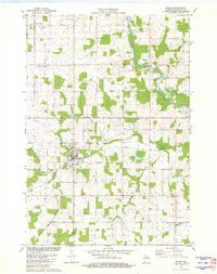
 1981 Marathon1982 Print · USGSMarathon County's agricultural heartland and the river valley near Marathon City are captured here in the early eighties. Genealogists and local historians can trace family locations near St Marys Cem, Rib Falls Ch, and the North Western rail line.
 - 1984 Map of Wausau, 1990 Print
 1984 Wausau1990 Print · USGSMarathon and Portage counties come into focus during the mid-eighties as industrial river towns and sprawling conservation areas define the Central Wisconsin landscape. Researchers can trace the rail corridors of the Soo Line or locate rural landmarks like Rib Mountain State Park and St Marys Cem.
End of results
Showing maps 1-5 of 5
Top cities near Cassel
- Wausau historical maps
- Marshfield historical maps
- Kronenwetter historical maps
- Rib Mountain historical maps
- Mosinee historical maps
- Maine historical maps
See more
Frequently asked questions
- What are the different types of historical maps available for Cassel?
- What is the oldest map of Cassel?
- Where can I purchase historical maps of Cassel for my home or office?
- Where can I download high-res historical maps of Cassel?
- Are there historical topographic maps available for Cassel?
- Is there historical aerial imagery available for Cassel?
- Where are historical maps of Cassel sourced from?