1950s Maps of Marinette County, Wisconsin
Explore 15 historic maps of Marinette County from the 1950s. These maps offer a rare glimpse into what life looked like during the 1950s — showing old roads, neighborhoods, homes, and landmarks that have changed or disappeared over time.
Whether you're researching your family's past, planning a metal detecting trip, or studying how Marinette County's landscape evolved across the 1950s, these high-resolution maps are a powerful tool for exploring the history of this region.
- Focus on a specific era: All maps on this page are from the 1950s, giving you a focused view of this time period.
- See what’s changed: Compare century-old streets, trails, and buildings to today's modern landscape using overlays and satellite layers.
- Research with precision: Use these maps for genealogy, historical research, land use analysis, or educational projects.
- View, download, or print: Maps are fully viewable online in high resolution, and can be downloaded or printed for your own records.
Start exploring Marinette County's history through authentic maps from the 1950s. This is your window into the past.
Marinette County, WI maps
(15)- 1950 Map of Coleman
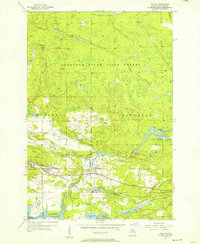
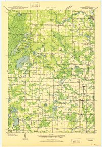 1950 Coleman1950 Print · USGSNortheastern Wisconsin comes alive in the mid-century as family farms and lakeside communities thrived between Marinette and Oconto counties. Genealogists and local historians can trace legacy sites like the Second Polish Ch, Victory Sch, and the vanished tracks of the St Paul and Pacific RR.
 - 1951 Map of Thunder Mountain, 1953 Print
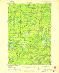 1951 Thunder Mountain1953 Print · USGSMarinette and Oconto counties are shown here in the early 1950s, showcasing a landscape of dense timber and river-driven history. Genealogists and historians can locate the Shady Nook Sch, the Fish Hatchery, and fire-watch posts like the Thunder Mountain Lookout Tower.3 unique versions available
 - 1952 Map of Mountain, 1955 Print
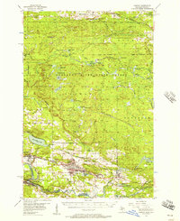
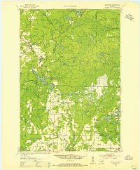 1952 Mountain1955 Print · USGSOconto County in the early fifties shows a patchwork of timberland and early farmsteads connected by the North Western railroad. Trace family sites at Breed and Frostville, or locate rural landmarks like the Breed Cemetery and Mountain Lookout Tower.2 unique versions available
 - 1954 Map of Iron Mountain, 1964 Print
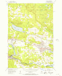
 1954 Iron Mountain1964 Print · USGSUpper Michigan and Northeastern Wisconsin are shown in detail during the mid-fifties, when the logging and mining economies still moved by rail. Trace the rail lines of the Soo Line to remote stops like Koepenick Station or explore the Iron Range near Iron Mountain.2 unique versions available
 - 1954 Map of Escanaba, 1967 Print
 1954 Escanaba1967 Print · USGSThe Upper Peninsula and Door County shorelines meet here in the mid-fifties, showing the vital maritime and timber networks of the Great Lakes. Researchers can trace historic rail lines, old fire lookouts like the Stonington Fire Tower, and island settlements such as Washington Island.2 unique versions available
 - 1954 Map of Manitowoc, 1968 Print
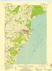
 1954 Manitowoc1968 Print · USGSLake Michigan served as a vital transit corridor in the mid-fifties, with car and auto ferries linking the industrial ports of Wisconsin to the Michigan timberlands. Genealogists and maritime historians can trace active ferry routes like the Ann Arbor Railway Car and Auto Ferry and locate early settlements from Brussels to Algoma.2 unique versions available
 - 1955 Map of Norway, 1957 Print
 1955 Norway1957 Print · USGSMid-century Dickinson County was a landscape defined by its iron-mining heritage and the powerful Menominee River. Genealogists and industrial historians can trace inactive sites like Aragon Mine or find ancestors at St Anthony Cem and Norway Cemetery.3 unique versions available
 - 1955 Map of Vulcan, 1957 Print
 1955 Vulcan1957 Print · USGSMid-century Dickinson County was a hub of Menominee Range iron mining and heavy rail activity. Genealogists and industrial historians can trace the foundations of Vulcan and Loretto, or locate the specific footprints of the Loretta Mine and Appleton Mine.2 unique versions available
 - 1955 Map of Norway, 1957 Print
 1955 Norway1957 Print · USGSUpper Peninsula mining towns and state forests thrive in the mid-fifties as the rail-and-river economy transitions. Researchers can trace the industrial footprint of the Aragon Mine, find the Norway Sch, and locate the St Anthony Cem.3 unique versions available
 - 1955 Map of Iron Mountain, 1957 Print
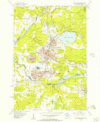 1955 Iron Mountain1957 Print · USGSIron Mountain and Kingsford thrive as industrial hubs in the mid-fifties, shaped by deep-shaft mining and the Menominee River. Genealogists can locate family homes near the American Martyrs Sch or trace the rail sidings serving the Trader Mine and Globe Mine.3 unique versions available
 - 1956 Map of Oconto, 1957 Print
 1956 Oconto1957 Print · USGSCoastal Oconto County at the mid-century mark shows a landscape of busy riverfronts and dense rural school districts. Genealogists can trace family roots through numerous country schools like Victory Sch and Brick Sch, or locate old lakeside settlements such as Pensaukee and Oak Orchard.2 unique versions available
 - 1957 Map of Escanaba
 1957 Escanaba1957 Print · USGSThe Upper Peninsula and Door County shorelines meet in the mid-fifties, capturing a landscape of timber, iron, and maritime trade. Genealogists and local historians can trace the Chicago & North Western RR through settlements like Hermansville or locate St Vitals Church and the Potawatome Indian Reservation.
 - 1958 Map of Escanaba
 1958 Escanaba1958 Print · USGSNorthern Lake Michigan maritime commerce and timberlands are captured here in the mid-fifties. Genealogists and historians can trace rail networks like the Escanaba and Lake Superior or locate island settlements such as Detroit Harbor and Fish Creek.
 - 1958 Map of Manitowoc
 1958 Manitowoc1958 Print · USGSLake Michigan and its shorelines are shown in the late fifties when maritime transport defined the region. Researchers can trace the routes of the Ann Arbor Railroad Ferry or locate old settlements like St. Nazianz, Rostock, and Two Creeks.
 - 1959 Map of Iron Mountain
 1959 Iron Mountain1959 Print · USGSThe northwoods of Wisconsin and the Michigan border are captured here in the mid-fifties, showing a landscape defined by timber, water, and rail. Researchers can trace historic junctions like Hiles Junction, the expansive Nicolet National Forest, and lakefront settlements from Rhinelander to Tomahawk.2 unique versions available
End of results
Showing maps 1-15 of 15
Top cities of Marinette County
- Marinette historical maps
- Peshtigo historical maps
- Peshtigo historical maps
- Porterfield historical maps
- Niagara historical maps
- Dunbar historical maps
See more
Frequently asked questions
- What are the different types of historical maps available for Marinette County?
- What is the oldest map of Marinette County?
- Where can I purchase historical maps of Marinette County for my home or office?
- Where can I download high-res historical maps of Marinette County?
- Are there historical topographic maps available for Marinette County?
- Is there historical aerial imagery available for Marinette County?
- Where are historical maps of Marinette County sourced from?