1930s Maps of Marinette County, Wisconsin
Explore 6 historic maps of Marinette County from the 1930s. These maps offer a rare glimpse into what life looked like during the 1930s — showing old roads, neighborhoods, homes, and landmarks that have changed or disappeared over time.
Whether you're researching your family's past, planning a metal detecting trip, or studying how Marinette County's landscape evolved across the 1930s, these high-resolution maps are a powerful tool for exploring the history of this region.
- Focus on a specific era: All maps on this page are from the 1930s, giving you a focused view of this time period.
- See what’s changed: Compare century-old streets, trails, and buildings to today's modern landscape using overlays and satellite layers.
- Research with precision: Use these maps for genealogy, historical research, land use analysis, or educational projects.
- View, download, or print: Maps are fully viewable online in high resolution, and can be downloaded or printed for your own records.
Start exploring Marinette County's history through authentic maps from the 1930s. This is your window into the past.
Marinette County, WI maps
(6)- 1939 Map of Marinette
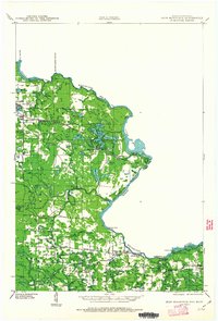
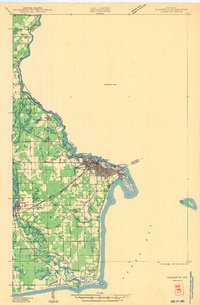 1939 Marinette1939 Print · USGSThe Green Bay shoreline and the Menominee River border come to life in the late 1930s as industrial and rural landscapes intersect. Genealogists can trace family footprints through numerous rural schools like Garfield Sch and Columbus Sch or the settlement at Winesville.
 - 1939 Map of Pembine, 1941 Print
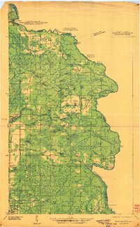 1939 Pembine1941 Print · USGSThe Menominee River borderlands in the late thirties showcase a landscape of granite quarries, rail junctions, and river falls. Trace early settlements and infrastructure including Pembine, the Chalk Hill Dam, and the St Anthony Cem.2 unique versions available
 - 1939 Map of Porterfield, 1952 Print
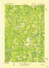
 1939 Porterfield1952 Print · USGSMarinette County was a landscape of timber, power, and scattered rural schoolhouses in the years just before the war. Genealogists can trace family roots through dozens of local landmarks like Behnke Sch, St Johns Ch, and the Harmony Cem.
 - 1939 Map of Dunbar, 1955 Print
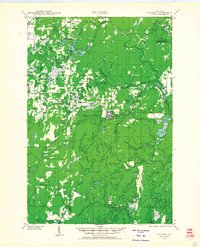
 1939 Dunbar1955 Print · USGSThe town of Dunbar and surrounding Marinette County lands are shown here in the late 1930s, caught between the era of heavy rail and emerging forest roads. You can trace early schoolhouses like McKinley Sch, find landmarks like the Dunbar Fire Tower, and locate the crossing at Carney Rapids.2 unique versions available
 - 1939 Map of Goodman, 1956 Print
 1939 Goodman1956 Print · USGSMarinette and Forest counties are shown just before the war when the timber economy and the railroad were the lifeblood of the Northwoods. Genealogists and local historians can trace early settlements at Goodman and Fence, alongside rural landmarks like Engleking Sch and Pine Hill Cem.
 - 1939 Map of Iron Mountain, 1963 Print
 1939 Iron Mountain1963 Print · USGSThe Menominee River borderlands at the end of the 1930s show a landscape of hydroelectric power and deep-woods settlements. Genealogists and historians can trace rural school districts like Golden Rule Sch and early industrial sites such as the Henry Ford Dam.
End of results
Showing maps 1-6 of 6
Top cities of Marinette County
- Marinette historical maps
- Peshtigo historical maps
- Peshtigo historical maps
- Porterfield historical maps
- Niagara historical maps
- Dunbar historical maps
See more
Frequently asked questions
- What are the different types of historical maps available for Marinette County?
- What is the oldest map of Marinette County?
- Where can I purchase historical maps of Marinette County for my home or office?
- Where can I download high-res historical maps of Marinette County?
- Are there historical topographic maps available for Marinette County?
- Is there historical aerial imagery available for Marinette County?
- Where are historical maps of Marinette County sourced from?