Old Maps of Marinette County, Wisconsin for Metal Detecting
Plan your next treasure hunt with 164 historic maps of Marinette County. Find old homesites, ghost towns, trails, and gathering spots that may be lost to time — perfect for identifying promising metal detecting locations.
- Locate forgotten sites: Uncover places like long-lost settlements, abandoned rail lines, or gathering spots.
- Plan better hunts: Use map overlays combined with LiDAR or satellite views to narrow in on historically rich areas.
- Made for detectorists: Thousands of hobbyists use these maps to discover relics, coins, and hidden history.
Use these historic maps to boost your research and find new opportunities beneath the surface of Marinette County.
Marinette County, WI maps
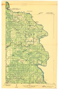
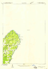
(164)- 1939 Map of Marinette
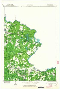
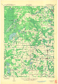
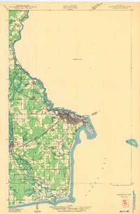 1939 Marinette1939 Print · USGSThe Green Bay shoreline and the Menominee River border come to life in the late 1930s as industrial and rural landscapes intersect. Genealogists can trace family footprints through numerous rural schools like Garfield Sch and Columbus Sch or the settlement at Winesville.
 - 1939 Map of Pembine, 1941 Print
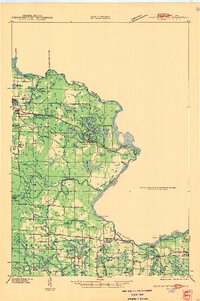
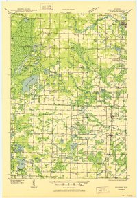
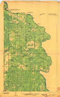 1939 Pembine1941 Print · USGSThe Menominee River borderlands in the late thirties showcase a landscape of granite quarries, rail junctions, and river falls. Trace early settlements and infrastructure including Pembine, the Chalk Hill Dam, and the St Anthony Cem.2 unique versions available
 - 1939 Map of Porterfield, 1952 Print
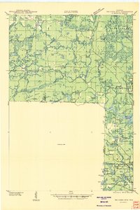
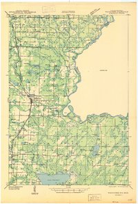
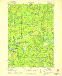
 1939 Porterfield1952 Print · USGSMarinette County was a landscape of timber, power, and scattered rural schoolhouses in the years just before the war. Genealogists can trace family roots through dozens of local landmarks like Behnke Sch, St Johns Ch, and the Harmony Cem.
 - 1939 Map of Dunbar, 1955 Print
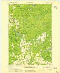
 1939 Dunbar1955 Print · USGSThe town of Dunbar and surrounding Marinette County lands are shown here in the late 1930s, caught between the era of heavy rail and emerging forest roads. You can trace early schoolhouses like McKinley Sch, find landmarks like the Dunbar Fire Tower, and locate the crossing at Carney Rapids.2 unique versions available
 - 1939 Map of Goodman, 1956 Print
 1939 Goodman1956 Print · USGSMarinette and Forest counties are shown just before the war when the timber economy and the railroad were the lifeblood of the Northwoods. Genealogists and local historians can trace early settlements at Goodman and Fence, alongside rural landmarks like Engleking Sch and Pine Hill Cem.
 - 1939 Map of Iron Mountain, 1963 Print
 1939 Iron Mountain1963 Print · USGSThe Menominee River borderlands at the end of the 1930s show a landscape of hydroelectric power and deep-woods settlements. Genealogists and historians can trace rural school districts like Golden Rule Sch and early industrial sites such as the Henry Ford Dam.
 - 1940 Map of Thunder Mtn.
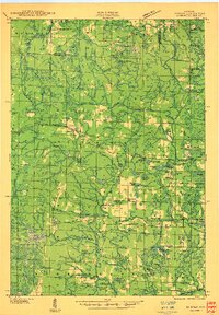
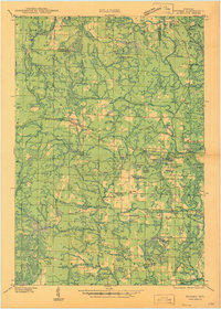
 1940 Thunder Mtn.1940 Print · USGSMarinette County and the surrounding woods are captured here in the early 1940s as a hub of timber production and forestry management. Genealogists and historians can trace rural schools like Silver Cliff Sch, the site of the State Fish Hatchery, and fire lookouts atop Thunder Mountain.2 unique versions available
 - 1940 Map of Athelstane, 1969 Print
 1940 Athelstane1969 Print · USGSMarinette County was a hub of hydroelectric power and timber management during the 1940s. Researchers can trace rural school districts like Newton Lakes School or locate the specialized Molybdenite Mine near the village of Athelstane.
 - 1941 Map of Dunbar
 1941 Dunbar1941 Print · USGSMarinette and Florence Counties are shown here just before the war, when rail lines and rural schools still defined northern Wisconsin life. Genealogists and historians can trace families near Dunbar or locate local landmarks like the Dunbar Fire Tower and Merriman Sch.
 - 1941 Map of Iron Mountain
 1941 Iron Mountain1941 Print · USGSThe Menominee River borderlands thrive with hydroelectric power and iron mining during the late thirties. Genealogists can trace family footprints at Woodlawn Cem or find early rural schoolhouses like Golden Rule Sch and Hauserman Sch.
 - 1941 Map of Coleman, 1965 Print
 1941 Coleman1965 Print · USGSMarinette and Oconto counties during the early 1940s show a landscape of timber, water power, and tight-knit rural communities. Genealogists can locate family-named landmarks like Gaffney L and numerous local schools such as Woodrow Wilson Sch and Goldfield Sch.2 unique versions available
 - 1942 Map of Athelstane
 1942 Athelstane1942 Print · USGSMarinette County was a landscape of timber and hydropower in the early 1940s. Genealogists and historians can trace defunct rural schools like Rector Sch and Konsted Sch, or locate industrial sites such as the Molybdenite Mine.
 - 1942 Map of Coleman
 1942 Coleman1942 Print · USGSThe rural Marinette and Oconto county lines are captured here in the early 1940s, a landscape defined by timber, small-scale farming, and the Peshtigo River. Researchers can trace old school districts like Woodrow Wilson Sch and historic local landmarks such as St Wenceslaus Ch and Sandstone Dam.
 - 1942 Map of Breed
 1942 Breed1942 Print · USGSMarinette and Oconto counties appear here in the early 1940s, showing a mix of established survey lines and wilder interior lands. Local researchers can trace the early courses of Peshtigo Brook and the West Branch through the township of Stephenson.
 - 1942 Map of Porterfield
 1942 Porterfield1942 Print · USGSMarinette and Oconto counties are documented here in the early 1940s, showing a landscape defined by the Peshtigo River and its many rural school districts. Researchers can find dozens of local landmarks, including Bagley Junction, Harmony Cem, and the Potato Rapids Power Dam.
 - 1942 Map of Wausaukee
 1942 Wausaukee1942 Print · USGSMarinette County in the early 1940s was a landscape of timber-towns and railroads winding toward the Michigan border. Genealogists can locate family-named rural schools like Shanebrook Sch and Gallow Sch or trace the early community at WAUSAUKEE.
 - 1946 Map of Goodman
 1946 Goodman1946 Print · USGSMarinette and Florence counties were still deeply tied to the timber industry and rail transit just before the 1940s. Genealogists and historians can trace local family roots at Pine Hill Cem or locate rural landmarks like Engleking Sch and the Goodman Fire Tower.
 - 1947 Map of Pembine
 1947 Pembine1947 Print · USGSMarinette County was a landscape of stone quarries and timber-line railroads just after World War II. Researchers can trace rural life through sites like Dixon Sch, the Reformatory Quarry, and the Mission Chapel near Kremlin.
 - 1947 Map of Dunbar
 1947 Dunbar1947 Print · USGSNortheastern Wisconsin’s logging and rail history is on full display here in the late 1940s, centered on the junction at Dunbar. Local historians can trace the paths of two major railroads and locate vanished community landmarks like the Dunbar Fire Tower and Pike Ridge Sch.
 - 1947 Map of Iron Mountain
 1947 Iron Mountain1947 Print · USGSAs the post-war industrial era took hold, this borderland map reveals a landscape of hydroelectric dams and iron-town settlements along the Menominee River. Genealogists and local historians can locate several rural schoolhouses, including Golden Rule Sch and Roach Sch, and trace the path of the Chicago and Northwestern Railroad.
 - 1947 Map of Wausaukee
 1947 Wausaukee1947 Print · USGSMarinette County in the late nineteen-forties centers on the village of Wausaukee and its surrounding glacial lake country. Trace the locations of rural schoolhouses like Shanebrook Sch and Gallow Sch, or locate family sites near Cedarville and the Pine Hill Cem.
 - 1949 Map of Stephenson
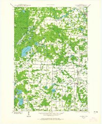
 1949 Stephenson1949 Print · USGSThe Menominee River borderlands are shown in detail during the late 1940s, highlighting the transition from timber extraction to settled rural life. Researchers can trace the Old Logging Railroad Grade and locate community landmarks like the McAllister Sch and Goll Cem.
 - 1950 Map of Coleman
 1950 Coleman1950 Print · USGSNortheastern Wisconsin comes alive in the mid-century as family farms and lakeside communities thrived between Marinette and Oconto counties. Genealogists and local historians can trace legacy sites like the Second Polish Ch, Victory Sch, and the vanished tracks of the St Paul and Pacific RR.
 - 1951 Map of Thunder Mountain, 1953 Print
 1951 Thunder Mountain1953 Print · USGSMarinette and Oconto counties are shown here in the early 1950s, showcasing a landscape of dense timber and river-driven history. Genealogists and historians can locate the Shady Nook Sch, the Fish Hatchery, and fire-watch posts like the Thunder Mountain Lookout Tower.3 unique versions available
 - 1952 Map of Mountain, 1955 Print
 1952 Mountain1955 Print · USGSOconto County in the early fifties shows a patchwork of timberland and early farmsteads connected by the North Western railroad. Trace family sites at Breed and Frostville, or locate rural landmarks like the Breed Cemetery and Mountain Lookout Tower.2 unique versions available
Showing maps 1-25 of 164
Top cities of Marinette County
- Marinette historical maps
- Peshtigo historical maps
- Peshtigo historical maps
- Porterfield historical maps
- Niagara historical maps
- Dunbar historical maps
See more
Frequently asked questions
- What are the different types of historical maps available for Marinette County?
- What is the oldest map of Marinette County?
- Where can I purchase historical maps of Marinette County for my home or office?
- Where can I download high-res historical maps of Marinette County?
- Are there historical topographic maps available for Marinette County?
- Is there historical aerial imagery available for Marinette County?
- Where are historical maps of Marinette County sourced from?