1970s Maps of Stephenson, Wisconsin
Explore 6 historic maps of Stephenson from the 1970s. These maps offer a rare glimpse into what life looked like during the 1970s — showing old roads, neighborhoods, homes, and landmarks that have changed or disappeared over time.
Whether you're researching your family's past, planning a metal detecting trip, or studying how Stephenson's landscape evolved across the 1970s, these high-resolution maps are a powerful tool for exploring the history of this region.
- Focus on a specific era: All maps on this page are from the 1970s, giving you a focused view of this time period.
- See what’s changed: Compare century-old streets, trails, and buildings to today's modern landscape using overlays and satellite layers.
- Research with precision: Use these maps for genealogy, historical research, land use analysis, or educational projects.
- View, download, or print: Maps are fully viewable online in high resolution, and can be downloaded or printed for your own records.
Start exploring Stephenson's history through authentic maps from the 1970s. This is your window into the past.
Stephenson, WI maps
(6)- 1972 Map of High Falls Reservoir, 1975 Print
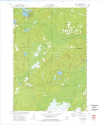
 1972 High Falls Reservoir1975 Print · USGSMarinette County’s river-driven industry and shoreline recreation are in full focus here during the early seventies. Trace the engineering of the Caldron Falls and High Falls dams or explore local landmarks like Thunder Mountain and Veterans Memorial Park.
 - 1972 Map of Thunder Mountain, 1975 Print
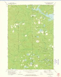 1972 Thunder Mountain1975 Print · USGSThe Marinette and Oconto county line runs through this forested landscape during the 1970s, dominated by the waters of the Peshtigo River. Researchers can trace old forest routes and local landmarks like the Thunder River State Rearing Station and Camp Bird State Youth Recreational Center.2 unique versions available
 - 1972 Map of Mount Tom, 1975 Print
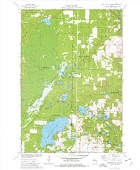
 1972 Mount Tom1975 Print · USGSMarinette County’s lake-dotted landscape is captured here in the early 1970s, showing the rural intersections of the Northwoods. Genealogists and hikers can trace old routes like Moonshine Hill Road or locate landmarks like the Lookout Tower and Retcof Lake.
 - 1973 Map of Shay Lake, 1977 Print
 1973 Shay Lake1977 Print · USGSThe Northwoods of Oconto County are shown here in the 1970s, revealing a landscape defined by timber, glacial lakes, and the Nicolet National Forest. Researchers can trace old logging routes and rural landmarks like Butler Rock, St Marys of the Lake Ch, and the remote Landing Strip.
 - 1973 Map of White Potato Lake, 1977 Print
 1973 White Potato Lake1977 Print · USGSThe Marinette County lake country is captured here in the early seventies, just as modern conservation efforts were shaping the land. Genealogists and historians can locate Brazeau Cem, the Patz Landing Field, and the many family-named waters like Heisel Lake.
 - 1973 Map of Crivitz, 1977 Print
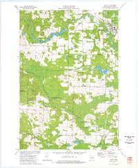 1973 Crivitz1977 Print · USGSCrivitz and the Peshtigo River valley are shown in the early seventies, capturing a landscape where the Northwoods timber heritage meets mid-century recreation. You can trace the path of the Milwaukee Road railroad and locate rural landmarks like the Beaver Lookout Tower and Sandstone Dam.
End of results
Showing maps 1-6 of 6
Top cities near Stephenson
- Beaver historical maps
- Crivitz historical maps
- Lakewood historical maps
- Amberg historical maps
- Mountain historical maps
- Coleman historical maps
See more
Frequently asked questions
- What are the different types of historical maps available for Stephenson?
- What is the oldest map of Stephenson?
- Where can I purchase historical maps of Stephenson for my home or office?
- Where can I download high-res historical maps of Stephenson?
- Are there historical topographic maps available for Stephenson?
- Is there historical aerial imagery available for Stephenson?
- Where are historical maps of Stephenson sourced from?