1970s Maps of Riverview, Wisconsin
Explore 6 historic maps of Riverview from the 1970s. These maps offer a rare glimpse into what life looked like during the 1970s — showing old roads, neighborhoods, homes, and landmarks that have changed or disappeared over time.
Whether you're researching your family's past, planning a metal detecting trip, or studying how Riverview's landscape evolved across the 1970s, these high-resolution maps are a powerful tool for exploring the history of this region.
- Focus on a specific era: All maps on this page are from the 1970s, giving you a focused view of this time period.
- See what’s changed: Compare century-old streets, trails, and buildings to today's modern landscape using overlays and satellite layers.
- Research with precision: Use these maps for genealogy, historical research, land use analysis, or educational projects.
- View, download, or print: Maps are fully viewable online in high resolution, and can be downloaded or printed for your own records.
Start exploring Riverview's history through authentic maps from the 1970s. This is your window into the past.
Riverview, WI maps
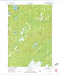
(6)- 1972 Map of Wheeler Lake, 1975 Print
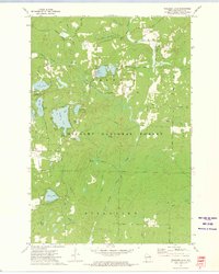 1972 Wheeler Lake1975 Print · USGSOconto County's lake-rich landscape is captured in the early 1970s, showcasing the intricate water systems within the Nicolet National Forest. You can trace an old railroad grade, locate the Lakewood State Fish Hatchery, or find family-named landmarks like Bucks Ranch.
 - 1972 Map of Thunder Mountain, 1975 Print
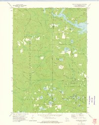 1972 Thunder Mountain1975 Print · USGSThe Marinette and Oconto county line runs through this forested landscape during the 1970s, dominated by the waters of the Peshtigo River. Researchers can trace old forest routes and local landmarks like the Thunder River State Rearing Station and Camp Bird State Youth Recreational Center.2 unique versions available
 - 1972 Map of Townsend, 1975 Print
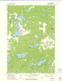 1972 Townsend1975 Print · USGSOconto County's timber and lake country is captured in the early seventies, when the Chicago and North Western railroad still served the northern woods. Trace family history at Forest Home Cem or locate the Archibald Lookout Tower near Townsend and Lakewood.2 unique versions available
 - 1973 Map of Mountain
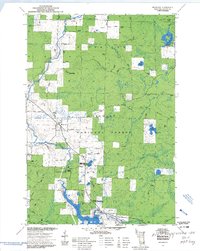 1973 Mountain1973 Print · USGSMountain and the surrounding Oconto River valley are shown in the early seventies as a hub for timber and recreation. Trace the development of Chute Pond, locate the St Michael Chapel, and explore landmarks like Bowman Airport.3 unique versions available
 - 1973 Map of Shay Lake, 1977 Print
 1973 Shay Lake1977 Print · USGSThe Northwoods of Oconto County are shown here in the 1970s, revealing a landscape defined by timber, glacial lakes, and the Nicolet National Forest. Researchers can trace old logging routes and rural landmarks like Butler Rock, St Marys of the Lake Ch, and the remote Landing Strip.
 - 1973 Map of Shadow Lake, 1977 Print
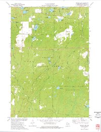 1973 Shadow Lake1977 Print · USGSOconto County's lake country is captured here in the early seventies, spanning the wooded borders of Doty and Riverview. Researchers can trace old routes like Old Grave Rd and locate landmarks ranging from the Townhall to the shores of Deadman Lake.
End of results
Showing maps 1-6 of 6
Top cities near Riverview
- Laona historical maps
- Wabeno historical maps
- Townsend historical maps
- Spruce historical maps
- Lakewood historical maps
- Mountain historical maps
See more
Frequently asked questions
- What are the different types of historical maps available for Riverview?
- What is the oldest map of Riverview?
- Where can I purchase historical maps of Riverview for my home or office?
- Where can I download high-res historical maps of Riverview?
- Are there historical topographic maps available for Riverview?
- Is there historical aerial imagery available for Riverview?
- Where are historical maps of Riverview sourced from?