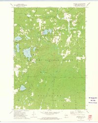
1972 Map of Wheeler Lake
USGS Topo · Published 1975About this map
The Oconto River and its numerous tributaries, including Sullivan Creek and Thunder Creek, define this 1970s landscape within the Nicolet National Forest. This region of Oconto County is characterized by a dense concentration of glacial lakes, from the large basins of Wheeler Lake and Waubee Lake to smaller waters like Bullfrog Lake and Bear Lake. Natural resources and conservation efforts are evident through the Lakewood State Fish Hatchery and several public access points. Historical transportation and land use patterns appear in the form of an old railroad grade and the presence of Bucks Ranch. Local landmarks such as Mary Park, Hickey Springs, and the cascading Snow Falls further illustrate the area's geography. This map provides a look at the Wisconsin Northwoods before more modern developments, showing old routes like Old 32 and Riverside Road.
Find a feature on this map
55 named features on this map. Tap any name to fly to it.
Don’t see what you’re looking for? This feature index may not catch every label — zoom into the map to look around manually.
Map Details
Editions of this 1972 Wheeler Lake Map
This is the sole edition of this map. No revisions or reprints were ever made.
Other maps of this area

1940 · Thunder Mtn.
USGS Topo · 1:48,000

1942 · Breed
USGS Topo · 1:48,000

1942 · Wabeno
USGS Topo · 1:48,000

1950 · Wabeno
USGS Topo · 1:48,000

1951 · Wabeno
USGS Topo · 1:48,000

1951 · Thunder Mountain
USGS Topo · 1:48,000

1952 · Langlade
USGS Topo · 1:48,000

1952 · Mountain
USGS Topo · 1:48,000

1954 · Iron Mountain
USGS Topo · 1:250,000

1959 · Iron Mountain
USGS Topo · 1:250,000