1970s Maps of Portage County, Wisconsin
Explore 12 historic maps of Portage County from the 1970s. These maps offer a rare glimpse into what life looked like during the 1970s — showing old roads, neighborhoods, homes, and landmarks that have changed or disappeared over time.
Whether you're researching your family's past, planning a metal detecting trip, or studying how Portage County's landscape evolved across the 1970s, these high-resolution maps are a powerful tool for exploring the history of this region.
- Focus on a specific era: All maps on this page are from the 1970s, giving you a focused view of this time period.
- See what’s changed: Compare century-old streets, trails, and buildings to today's modern landscape using overlays and satellite layers.
- Research with precision: Use these maps for genealogy, historical research, land use analysis, or educational projects.
- View, download, or print: Maps are fully viewable online in high resolution, and can be downloaded or printed for your own records.
Start exploring Portage County's history through authentic maps from the 1970s. This is your window into the past.
Portage County, WI maps
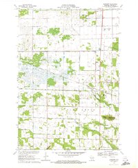
(12)- 1970 Map of Kellner, 1972 Print
 1970 Kellner1972 Print · USGSThe rural border of Wood and Portage Counties was a landscape of managed waterways and rail lines in the 1970s. Genealogists and local historians can trace the community around Kellner, finding landmarks like St Johns Cem, Grant Sch, and the Church of God.
 - 1970 Map of Junction City, 1972 Print
 1970 Junction City1972 Print · USGSJunction City and Milladore sit at a vital rail crossing in central Wisconsin as the seventies began. Genealogists and rail historians can trace the intersection of the Soo Line and Chicago Milwaukee St Paul and Pacific, alongside local landmarks like St Wenceslaus Cem and Fogarty Marsh.
 - 1970 Map of Stevens Point, 1972 Print
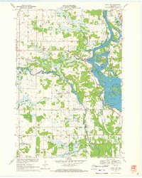
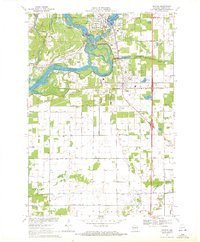
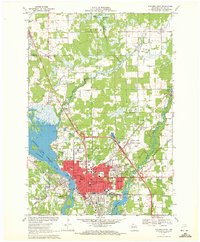 1970 Stevens Point1972 Print · USGSStevens Point and the Wisconsin River corridor are captured here at a peak of mid-century development. Researchers can trace the footprints of Wisconsin State University and local history at St Stephens Cem, McDill Pond, and the Soo Line tracks.4 unique versions available
 - 1970 Map of Bancroft, 1972 Print
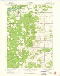
 1970 Bancroft1972 Print · USGSPortage County at the start of the seventies reveals a landscape of reclaimed marshlands and rail-dependent hamlets. Genealogists and local historians can trace the foundations of Bancroft and West Bancroft alongside landmarks like Mosquito Bluff and the Pine Grove Cem.2 unique versions available
 - 1970 Map of Rocky Run, 1972 Print
 1970 Rocky Run1972 Print · USGSThe Wisconsin River valley on the Portage and Wood county border comes to life in the early seventies, showing a landscape defined by water and woods. Genealogists and local historians can locate the Mill Creek Community, the Buelow Cem, and the marshy reaches of Fogarty Marsh.2 unique versions available
 - 1970 Map of Meehan, 1972 Print
 1970 Meehan1972 Print · USGSPortage County at the start of the seventies reveals a landscape defined by the expansive Wisconsin River Flowage and specialized agriculture. Researchers can locate the settlement of Meehan, the Linwood Union Cem, and regional landmarks like the Cranberry Bog.2 unique versions available
 - 1970 Map of Dewey Marsh, 1972 Print
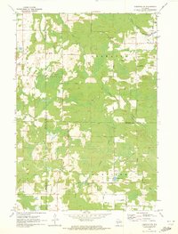
 1970 Dewey Marsh1972 Print · USGSMarathon and Portage counties come together in the early 1970s within the extensive wetlands and winding river systems of Central Wisconsin. Local historians can trace the rural layout of Rocky Corners, the high point of Blackberry Hill, and the unique Philippine Islands within Dewey Marsh.2 unique versions available
 - 1970 Map of Dancy, 1972 Print
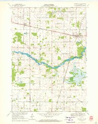
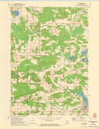
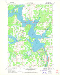 1970 Dancy1972 Print · USGSMarathon and Portage counties meet along the waters of Lake Du Bay in the early seventies, where the railroad still anchors local river towns. Genealogists and historians can trace the foundations of Knowlton and Dancy, locating landmarks like St Francis Ch and the Knowlton Sch.3 unique versions available
 - 1970 Map of Whiting, 1972 Print
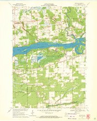
 1970 Whiting1972 Print · USGSPortage County at the start of the seventies shows a landscape defined by the winding Wisconsin River and the growing communities of Whiting and Plover. Researchers can trace old family sites near Maine Cem, St Bronislava, or the River Pines Sanatorium.2 unique versions available
 - 1970 Map of Tigerton NW, 1973 Print
 1970 Tigerton NW1973 Print · USGSNorth-central Wisconsin in the 1970s shows a landscape of dense water networks and forest land where four counties meet. Researchers can trace the OLD RAILROAD GRADE near Jackson Lake or locate the rural hub of Norske and its surrounding family-named roads.2 unique versions available
 - 1970 Map of Big Eau Pleine Reservoir, 1984 Print
 1970 Big Eau Pleine Reservoir1984 Print · USGSMarathon and Portage counties were defined by extensive wetland management and conservation efforts in the early seventies. Genealogists and outdoorsmen can trace landmarks like Runkle Cem, Big Eau Pleine County Park, and the winding Little Eau Pleine River.
 - 1971 Map of Iola, 1973 Print
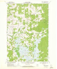
 1971 Iola1973 Print · USGSIola and its rural surroundings in Portage and Waupaca counties are shown here just after the turn of the 1970s. Researchers can trace the Old Railroad Grade near Iola Lake, find the Hitterdahl Cem, or locate the Ski Jump near Griffin.2 unique versions available
End of results
Showing maps 1-12 of 12
Top cities of Portage County
- Stevens Point historical maps
- Plover historical maps
- Stockton historical maps
- Whiting historical maps
- Amherst historical maps
- Alban historical maps
See more
Frequently asked questions
- What are the different types of historical maps available for Portage County?
- What is the oldest map of Portage County?
- Where can I purchase historical maps of Portage County for my home or office?
- Where can I download high-res historical maps of Portage County?
- Are there historical topographic maps available for Portage County?
- Is there historical aerial imagery available for Portage County?
- Where are historical maps of Portage County sourced from?