1950s Maps of Portage County, Wisconsin
Explore 10 historic maps of Portage County from the 1950s. These maps offer a rare glimpse into what life looked like during the 1950s — showing old roads, neighborhoods, homes, and landmarks that have changed or disappeared over time.
Whether you're researching your family's past, planning a metal detecting trip, or studying how Portage County's landscape evolved across the 1950s, these high-resolution maps are a powerful tool for exploring the history of this region.
- Focus on a specific era: All maps on this page are from the 1950s, giving you a focused view of this time period.
- See what’s changed: Compare century-old streets, trails, and buildings to today's modern landscape using overlays and satellite layers.
- Research with precision: Use these maps for genealogy, historical research, land use analysis, or educational projects.
- View, download, or print: Maps are fully viewable online in high resolution, and can be downloaded or printed for your own records.
Start exploring Portage County's history through authentic maps from the 1950s. This is your window into the past.
Portage County, WI maps
(10)- 1955 Map of Tigerton, 1957 Print
 1955 Tigerton1957 Print · USGSThe rural borderlands of Shawano and Waupaca Counties come alive in the mid-1950s, showing a landscape of small schools and river-fed mill towns. Genealogists can trace family landmarks like Alban Chapel, the Hitterdahl Ch, and old rural schoolhouses including Selmer Sch.2 unique versions available
 - 1955 Map of Rosholt, 1957 Print
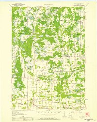 1955 Rosholt1957 Print · USGSPortage County’s rural landscape comes alive in the mid-fifties, showing the intersection of rail transport and small-town commerce. Researchers can trace family roots at St Marys Ch, locate vanished schoolhouses like Oakland Sch, or explore the rail corridor near Nelsonville.2 unique versions available
 - 1955 Map of Green Bay, 1968 Print
 1955 Green Bay1968 Print · USGSCentral and Eastern Wisconsin are captured here in the mid-fifties, showing the industrial growth of the Fox Valley and Wisconsin River corridors. Genealogists and historians can trace rail lines like the Green Bay and Western through settlements like Weyauwega, Clintonville, and Pulaski.2 unique versions available
 - 1956 Map of Milladore, 1958 Print
 1956 Milladore1958 Print · USGSIn the mid-fifties, this section of Wood County was a busy crossroads for the Soo Line and Milwaukee Road railroads. Genealogists can trace a lost network of rural education through sites like Steppingstone Sch, Lone Elm Sch, and the Runkle Sch.
 - 1956 Map of Stevens Point, 1958 Print
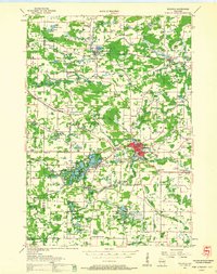
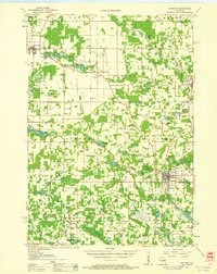
 1956 Stevens Point1958 Print · USGSStevens Point and the central Wisconsin River valley are captured here in the mid-fifties during a period of significant educational and infrastructure growth. Researchers can locate numerous country schools and religious landmarks, from St Francis Ch to the State Teachers College and the Cranberry Bog.2 unique versions available
 - 1957 Map of Amherst, 1959 Print
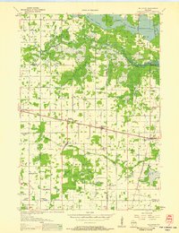
 1957 Amherst1959 Print · USGSPortage County at the end of the fifties is a landscape of intersecting railroads and rural school districts. Genealogists can trace family lines at Spiritland Cem or locate the site of the Lincoln Sch (Abandoned) near the Almond village limits.
 - 1957 Map of Waupaca, 1959 Print
 1957 Waupaca1959 Print · USGSWaupaca and the famous Chain O' Lakes are captured in the late fifties, showing a landscape of small lakeside settlements and rural schoolhouses. Researchers can find Waupaca Boys Camp, trace the old Green Bay and Western line, or locate King and Rural.2 unique versions available
 - 1957 Map of Whiting, 1959 Print
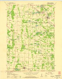
 1957 Whiting1959 Print · USGSCentral Wisconsin is captured here in the late fifties, showcasing the river-and-rail corridor connecting Whiting and Bancroft. Researchers can trace old rural schoolhouses like Pearl Sch and cemeteries such as McDill Cem across the Portage County landscape.
 - 1958 Map of Coloma, 1960 Print
 1958 Coloma1960 Print · USGSThe Central Wisconsin sand plains are shown during the late 1950s as small towns like Plainfield and Coloma flourished along the Chicago and North Western rail line. Genealogists can locate rural schoolhouses such as Rathermel Sch and family landmarks like Owens Rock.
 - 1959 Map of Wautoma, 1961 Print
 1959 Wautoma1961 Print · USGSWaushara County in the late fifties shows a rural landscape defined by glacial lakes and a developing transportation network. Genealogists can trace family names through numerous sites like Richford Cem, West Holden Ch, and St Pauls Cem.
End of results
Showing maps 1-10 of 10
Top cities of Portage County
- Stevens Point historical maps
- Plover historical maps
- Stockton historical maps
- Whiting historical maps
- Amherst historical maps
- Alban historical maps
See more
Frequently asked questions
- What are the different types of historical maps available for Portage County?
- What is the oldest map of Portage County?
- Where can I purchase historical maps of Portage County for my home or office?
- Where can I download high-res historical maps of Portage County?
- Are there historical topographic maps available for Portage County?
- Is there historical aerial imagery available for Portage County?
- Where are historical maps of Portage County sourced from?