1970s Maps of Dewey, Wisconsin
Explore 4 historic maps of Dewey from the 1970s. These maps offer a rare glimpse into what life looked like during the 1970s — showing old roads, neighborhoods, homes, and landmarks that have changed or disappeared over time.
Whether you're researching your family's past, planning a metal detecting trip, or studying how Dewey's landscape evolved across the 1970s, these high-resolution maps are a powerful tool for exploring the history of this region.
- Focus on a specific era: All maps on this page are from the 1970s, giving you a focused view of this time period.
- See what’s changed: Compare century-old streets, trails, and buildings to today's modern landscape using overlays and satellite layers.
- Research with precision: Use these maps for genealogy, historical research, land use analysis, or educational projects.
- View, download, or print: Maps are fully viewable online in high resolution, and can be downloaded or printed for your own records.
Start exploring Dewey's history through authentic maps from the 1970s. This is your window into the past.
Dewey, WI maps
(4)- 1970 Map of Stevens Point, 1972 Print
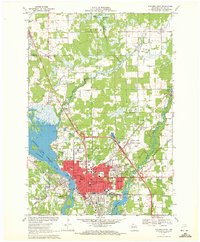 1970 Stevens Point1972 Print · USGSStevens Point and the Wisconsin River corridor are captured here at a peak of mid-century development. Researchers can trace the footprints of Wisconsin State University and local history at St Stephens Cem, McDill Pond, and the Soo Line tracks.4 unique versions available
 - 1970 Map of Rocky Run, 1972 Print
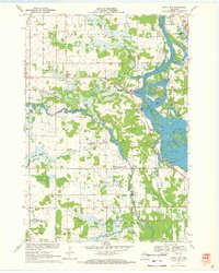 1970 Rocky Run1972 Print · USGSThe Wisconsin River valley on the Portage and Wood county border comes to life in the early seventies, showing a landscape defined by water and woods. Genealogists and local historians can locate the Mill Creek Community, the Buelow Cem, and the marshy reaches of Fogarty Marsh.2 unique versions available
 - 1970 Map of Dewey Marsh, 1972 Print
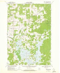 1970 Dewey Marsh1972 Print · USGSMarathon and Portage counties come together in the early 1970s within the extensive wetlands and winding river systems of Central Wisconsin. Local historians can trace the rural layout of Rocky Corners, the high point of Blackberry Hill, and the unique Philippine Islands within Dewey Marsh.2 unique versions available
 - 1970 Map of Dancy, 1972 Print
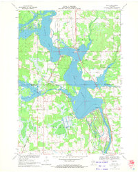 1970 Dancy1972 Print · USGSMarathon and Portage counties meet along the waters of Lake Du Bay in the early seventies, where the railroad still anchors local river towns. Genealogists and historians can trace the foundations of Knowlton and Dancy, locating landmarks like St Francis Ch and the Knowlton Sch.3 unique versions available
End of results
Showing maps 1-4 of 4
Top cities near Dewey
- Stevens Point historical maps
- Wisconsin Rapids historical maps
- Weston historical maps
- Plover historical maps
- Kronenwetter historical maps
- Rib Mountain historical maps
See more
Top neighborhoods of Dewey
Frequently asked questions
- What are the different types of historical maps available for Dewey?
- What is the oldest map of Dewey?
- Where can I purchase historical maps of Dewey for my home or office?
- Where can I download high-res historical maps of Dewey?
- Are there historical topographic maps available for Dewey?
- Is there historical aerial imagery available for Dewey?
- Where are historical maps of Dewey sourced from?