Old Maps of Dewey, Wisconsin for Metal Detecting
Plan your next treasure hunt with 16 historic maps of Dewey. Find old homesites, ghost towns, trails, and gathering spots that may be lost to time — perfect for identifying promising metal detecting locations.
- Locate forgotten sites: Uncover places like long-lost settlements, abandoned rail lines, or gathering spots.
- Plan better hunts: Use map overlays combined with LiDAR or satellite views to narrow in on historically rich areas.
- Made for detectorists: Thousands of hobbyists use these maps to discover relics, coins, and hidden history.
Use these historic maps to boost your research and find new opportunities beneath the surface of Dewey.
Dewey, WI maps
(16)- 1955 Map of Rosholt, 1957 Print
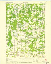 1955 Rosholt1957 Print · USGSPortage County’s rural landscape comes alive in the mid-fifties, showing the intersection of rail transport and small-town commerce. Researchers can trace family roots at St Marys Ch, locate vanished schoolhouses like Oakland Sch, or explore the rail corridor near Nelsonville.2 unique versions available
 - 1955 Map of Green Bay, 1968 Print
 1955 Green Bay1968 Print · USGSCentral and Eastern Wisconsin are captured here in the mid-fifties, showing the industrial growth of the Fox Valley and Wisconsin River corridors. Genealogists and historians can trace rail lines like the Green Bay and Western through settlements like Weyauwega, Clintonville, and Pulaski.2 unique versions available
 - 1956 Map of Stevens Point, 1958 Print
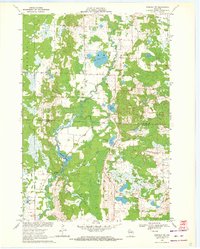
 1956 Stevens Point1958 Print · USGSStevens Point and the central Wisconsin River valley are captured here in the mid-fifties during a period of significant educational and infrastructure growth. Researchers can locate numerous country schools and religious landmarks, from St Francis Ch to the State Teachers College and the Cranberry Bog.2 unique versions available
 - 1969 Map of Rosholt NW, 1972 Print
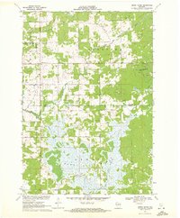
 1969 Rosholt NW1972 Print · USGSThe Marathon and Portage county line bisects this rural Wisconsin landscape during the late sixties, a region defined by its glacial lakes and river bends. Trace local roots around Shantytown or explore the waterways of Big Bass Lake and Bentley Pond.2 unique versions available
 - 1969 Map of Polonia, 1972 Print
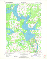
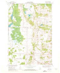 1969 Polonia1972 Print · USGSPortage County’s rural character is on full display in this late 1960s survey, showing a landscape shaped by parish life and glacial terrain. You can trace the Soo Line through Custer, find small schools like Sacred Heart Sch, and explore the vast Jordan Swamp.2 unique versions available
 - 1970 Map of Stevens Point, 1972 Print
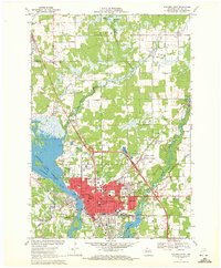 1970 Stevens Point1972 Print · USGSStevens Point and the Wisconsin River corridor are captured here at a peak of mid-century development. Researchers can trace the footprints of Wisconsin State University and local history at St Stephens Cem, McDill Pond, and the Soo Line tracks.4 unique versions available
 - 1970 Map of Rocky Run, 1972 Print
 1970 Rocky Run1972 Print · USGSThe Wisconsin River valley on the Portage and Wood county border comes to life in the early seventies, showing a landscape defined by water and woods. Genealogists and local historians can locate the Mill Creek Community, the Buelow Cem, and the marshy reaches of Fogarty Marsh.2 unique versions available
 - 1970 Map of Dewey Marsh, 1972 Print
 1970 Dewey Marsh1972 Print · USGSMarathon and Portage counties come together in the early 1970s within the extensive wetlands and winding river systems of Central Wisconsin. Local historians can trace the rural layout of Rocky Corners, the high point of Blackberry Hill, and the unique Philippine Islands within Dewey Marsh.2 unique versions available
 - 1970 Map of Dancy, 1972 Print
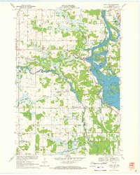
 1970 Dancy1972 Print · USGSMarathon and Portage counties meet along the waters of Lake Du Bay in the early seventies, where the railroad still anchors local river towns. Genealogists and historians can trace the foundations of Knowlton and Dancy, locating landmarks like St Francis Ch and the Knowlton Sch.3 unique versions available
 - 1984 Map of Wausau, 1990 Print
 1984 Wausau1990 Print · USGSMarathon and Portage counties come into focus during the mid-eighties as industrial river towns and sprawling conservation areas define the Central Wisconsin landscape. Researchers can trace the rail corridors of the Soo Line or locate rural landmarks like Rib Mountain State Park and St Marys Cem.
 - 2022 Map of Polonia, 2022 Print
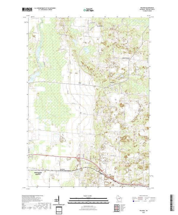 2022 Polonia2022 Print · USGSPortage County at the start of the 2020s reveals a patchwork of small crossroads communities and glacial water bodies. Genealogists and local historians can trace family-named routes and longstanding hamlets like Polonia, Ellis, and Custer.
 - 2022 Map of Rosholt NW, 2022 Print
 2022 Rosholt NW2022 Print · USGSMarathon and Portage counties are shown here in the 2020s, where the winding Plover River cuts through a dense glacial landscape. Researchers can locate the rural settlement of Shantytown and trace local access to Big Bass Lake and Twin Lakes.
 - 2022 Map of Dewey Marsh, 2022 Print
 2022 Dewey Marsh2022 Print · USGSMarathon and Portage counties come together in this 2020s study of the central Wisconsin wetlands and rural crossroads. Researchers can trace family-named routes like Zoromski Rd or locate small settlements at Rocky Corners and Ashley.
 - 2022 Map of Stevens Point, 2022 Print
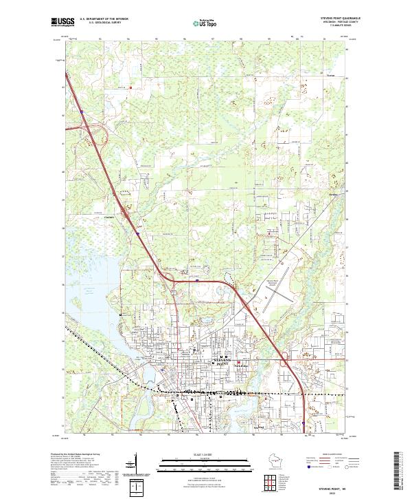 2022 Stevens Point2022 Print · USGSThe Wisconsin River corridor and the educational center of Stevens Point are shown here in the early 2020s. Genealogists and local historians can trace the area's development through the Portage County Courthouse, Soo Line RR, and several parish sites like Saint Josephs Cem.
 - 2022 Map of Rocky Run, 2022 Print
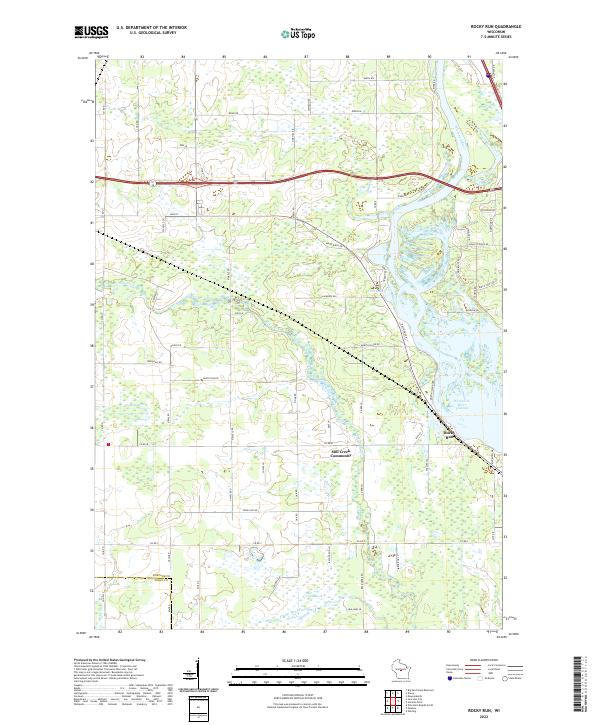 2022 Rocky Run2022 Print · USGSThe Wisconsin River shoreline and the quiet interior of Portage and Wood Counties are captured here as they appeared in 2022. Researchers can trace the local landscape from the Mill Creek Community to the wetlands of Fogarty Marsh and the waters of First Lake.
 - 2022 Map of Dancy, 2022 Print
 2022 Dancy2022 Print · USGSMarathon and Portage counties meet along the sprawling waters of the Wisconsin River in the early twenty-first century. Genealogists and local historians can trace the sites of Saint John the Baptist Cem, Knowlton, and Dancy.
End of results
Showing maps 1-16 of 16
Top cities near Dewey
- Stevens Point historical maps
- Wisconsin Rapids historical maps
- Weston historical maps
- Plover historical maps
- Kronenwetter historical maps
- Rib Mountain historical maps
See more
Top neighborhoods of Dewey
Frequently asked questions
- What are the different types of historical maps available for Dewey?
- What is the oldest map of Dewey?
- Where can I purchase historical maps of Dewey for my home or office?
- Where can I download high-res historical maps of Dewey?
- Are there historical topographic maps available for Dewey?
- Is there historical aerial imagery available for Dewey?
- Where are historical maps of Dewey sourced from?