2000-2009 Maps of Round Lake, Wisconsin
Explore 6 historic maps of Round Lake from 2000-2009. These maps offer a rare glimpse into what life looked like during the 2000s — showing old roads, neighborhoods, homes, and landmarks that have changed or disappeared over time.
Whether you're researching your family's past, planning a metal detecting trip, or studying how Round Lake's landscape evolved across the 2000s, these high-resolution maps are a powerful tool for exploring the history of this region.
- Focus on a specific era: All maps on this page are from the 2000s, giving you a focused view of this time period.
- See what’s changed: Compare century-old streets, trails, and buildings to today's modern landscape using overlays and satellite layers.
- Research with precision: Use these maps for genealogy, historical research, land use analysis, or educational projects.
- View, download, or print: Maps are fully viewable online in high resolution, and can be downloaded or printed for your own records.
Start exploring Round Lake's history through authentic maps from the 2000s. This is your window into the past.
Round Lake, WI maps
(6)- 2005 Map of Barker Lake, 2006 Print
 2005 Barker Lake2006 Print · USGSSawyer County’s intricate water systems and forest boundaries are clearly defined in this mid-2000s survey of the Wisconsin northwoods. Researchers can trace the sprawling reaches of Lake Chippewa, locate the Winter Dam, and identify landmarks like Big Timber Island.
 - 2005 Map of Spider Lake, 2006 Print
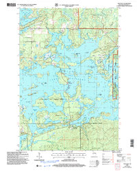
 2005 Spider Lake2006 Print · USGSThe Northwoods of Sawyer County appear here as a maze of glacial lakes and managed forest at the start of the millennium. Researchers can trace the shoreline of Spider Lake or locate specific landmarks like the Tiger Cat Dam and Camp Four Lakes.
 - 2005 Map of Clam Lake SW, 2006 Print
 2005 Clam Lake SW2006 Print · USGSNorthern Wisconsin lake country and timberlands are seen here in the early 2000s within the Chequamegon - Nicolet National Forest. Trace the path of the Chippewa River and explore the remote shores of Moose Lake and Ike Lake.
 - 2005 Map of New Post, 2006 Print
 2005 New Post2006 Print · USGSSawyer County’s lake country is captured here in the early 2000s, showing the intersection of forest service lands and tribal territory. Researchers can locate the New Post settlement and its Cem, alongside named landmarks like Hermans Landing and Pork Barrel Island.
 - 2005 Map of Blaisdell Lake, 2006 Print
 2005 Blaisdell Lake2006 Print · USGSThe Northwoods of Sawyer County come into focus during the mid-2000s, showcasing a landscape of glacial lakes managed within the Chequamegon-Nicolet National Forest. Trace local history at Glenwood Camp, the Power Plant, and old landings on Blaisdell Lake and Loretta Lake.
 - 2005 Map of Moose Lake, 2006 Print
 2005 Moose Lake2006 Print · USGSSawyer County lake country is shown in detail during the early 2000s, centered on the protected lands of the Chequamegon-Nicolet National Forest. You can locate old forest access points, the West Fork Lookout, and remote shoreline features on Moose Lake and Teal Lake.
End of results
Showing maps 1-6 of 6
Top cities near Round Lake
- Cable historical maps
- Drummond historical maps
- Winter historical maps
- Ojibwa historical maps
- Couderay historical maps
Frequently asked questions
- What are the different types of historical maps available for Round Lake?
- What is the oldest map of Round Lake?
- Where can I purchase historical maps of Round Lake for my home or office?
- Where can I download high-res historical maps of Round Lake?
- Are there historical topographic maps available for Round Lake?
- Is there historical aerial imagery available for Round Lake?
- Where are historical maps of Round Lake sourced from?