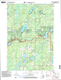
2005 Map of Blaisdell Lake
USGS Topo · Published 2006About this map
Chequamegon-Nicolet National Forest encompasses this water-rich pocket of the Northwoods, defined by a dense network of glacial lakes and river systems. The Chippewa River District Ranger Station sits centrally along the river's winding course, overseeing a landscape that balances recreational sites like Glenwood Camp and We Ha Kee Church Camp with local resource extraction at several Gravel Pits. The map documents a highly developed hydrological landscape where larger bodies like Blaisdell Lake and Fishtrap Lake are interconnected by creeks such as Venison Creek and Fishtrap Creek. Towards the southeastern corner, the presence of a Power Plant near the river and the Loretta Lake settlement area indicates the intersection of utility and community at the edge of the forest. The concentration of labeled boat ramps and a dedicated Snowmobile Trail reflect the region's long-standing identity as a hub for year-round outdoor activity.
Find a feature on this map
29 named features on this map. Tap any name to fly to it.
Don’t see what you’re looking for? This feature index may not catch every label — zoom into the map to look around manually.
Map Details
Editions of this 2005 Blaisdell Lake Map
This is the sole edition of this map. No revisions or reprints were ever made.
Other maps of this area

1942 · Clam Lake
USGS Topo · 1:48,000

1943 · Namekagon Lake
USGS Topo · 1:48,000

1944 · Draper
USGS Topo · 1:48,000

1944 · Radisson
USGS Topo · 1:48,000

1945 · Namekagon Lake
USGS Topo · 1:48,000

1945 · Clam Lake
USGS Topo · 1:48,000

1947 · Draper
USGS Topo · 1:48,000

1949 · Radisson
USGS Topo · 1:48,000

1953 · Ashland
USGS Topo · 1:250,000

1953 · Rice Lake
USGS Topo · 1:250,000