1940s Maps of Winter, Wisconsin
Explore 12 historic maps of Winter from the 1940s. These maps offer a rare glimpse into what life looked like during the 1940s — showing old roads, neighborhoods, homes, and landmarks that have changed or disappeared over time.
Whether you're researching your family's past, planning a metal detecting trip, or studying how Winter's landscape evolved across the 1940s, these high-resolution maps are a powerful tool for exploring the history of this region.
- Focus on a specific era: All maps on this page are from the 1940s, giving you a focused view of this time period.
- See what’s changed: Compare century-old streets, trails, and buildings to today's modern landscape using overlays and satellite layers.
- Research with precision: Use these maps for genealogy, historical research, land use analysis, or educational projects.
- View, download, or print: Maps are fully viewable online in high resolution, and can be downloaded or printed for your own records.
Start exploring Winter's history through authentic maps from the 1940s. This is your window into the past.
Winter, WI maps
(12)- 1941 Map of Kennan, 1952 Print
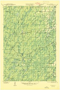
 1941 Kennan1952 Print · USGSIn the early 1940s, the rail-and-river corridor of Price and Rusk Counties supported a network of small timber and farm towns. Researchers can trace family-named landmarks and rural education hubs like Martins Hill Sch, the Harmony church, and the Soo Line railroad.2 unique versions available
 - 1941 Map of Kennedy, 1959 Print
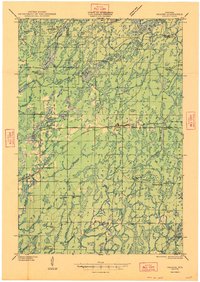
 1941 Kennedy1959 Print · USGSIn the early 1940s, this portion of Price and Sawyer counties was a landscape of timber management and rail-side settlements. Genealogists can locate rural schoolhouses like Poplar Hill Sch and trace industrial sites such as Pixley Dam or the Old Mill Dam.2 unique versions available
 - 1944 Map of Exeland, 1952 Print
 1944 Exeland1952 Print · USGSNorthern Wisconsin's river country is captured in the mid-1940s as rural life centered on local schools and the rail line. Genealogists can trace family footprints near Exeland or at one of many country schoolhouses like Murry Sch and Laurel Hill Sch.2 unique versions available
 - 1944 Map of Draper, 1952 Print
 1944 Draper1952 Print · USGSLogging and rail transport dominated the Sawyer County timberlands during the mid-forties. Genealogists and historians can locate former homesteads and work sites like Old Le May Camp, Loretta Cem, and the Barber Lake Sch.2 unique versions available
 - 1944 Map of Radisson, 1957 Print
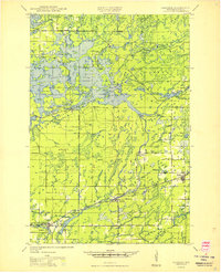
 1944 Radisson1957 Print · USGSSawyer County in the mid-1940s shows a landscape of timber and rail along the Chippewa River. Local historians can trace the Chicago and North Western Railway through Radisson or locate rural landmarks like Hunter Sch and New Post.2 unique versions available
 - 1945 Map of Kennedy
 1945 Kennedy1945 Print · USGSThe Wisconsin Northwoods come alive in the 1940s, showing a landscape of timber, rail, and remote settlements. Genealogists and local historians can trace rural schoolhouses like Arnold Sch and family landmarks near Lugerville and Kaiser.2 unique versions available
 - 1945 Map of Kennan
 1945 Kennan1945 Print · USGSPrice and Rusk counties appear here in the mid-1940s, showing the Northwoods at the height of its rail-and-timber era. Genealogists and local historians can trace family locations near village centers like Kennan and Hawkins or find rural landmarks like Forest Vale Sch and Kraft Camp.
 - 1945 Map of Ingram, 1967 Print
 1945 Ingram1967 Print · USGSThe Flambeau River basin comes into sharp focus in the mid-1940s, revealing a landscape of remote camps and early state forestry. Researchers can trace the rail corridor through Ingram or locate vanished sites like the CCC Rusk Camp (Abandoned) and Pioneer Sch.
 - 1947 Map of Exeland
 1947 Exeland1947 Print · USGSNorthwest Wisconsin's river country comes into focus in the 1940s as rural school districts and small homesteads still defined the landscape. Genealogists can locate family-named landmarks like Reppert School or Murry School and trace the original course of the Chippewa River.
 - 1947 Map of Ingram
 1947 Ingram1947 Print · USGSIn the Wisconsin Northwoods after the war, the Flambeau River basin was a landscape of timber management and hydroelectric power. Researchers can locate the CCC Rusk Camp, the Big Falls Dam, and rural landmarks like the Swedish Lutheran Cem.
 - 1947 Map of Draper
 1947 Draper1947 Print · USGSSawyer County is captured here in the late 1940s as its logging history gives way to reforestation and rural settlement. Genealogists can trace family footprints at Loretta Cem, Barber Lake Sch, and various sites like Old Savord Camp.2 unique versions available
 - 1949 Map of Radisson
 1949 Radisson1949 Print · USGSSawyer County's timber and rail landscape is captured here in the mid-1940s, showing the early development of the Chippewa River valley. Researchers can trace historic local sites like New Post, the Bishop Bridge Sch, and the Chicago and North Western rail line.
End of results
Showing maps 1-12 of 12
Top cities near Winter
Top neighborhoods of Winter
Frequently asked questions
- What are the different types of historical maps available for Winter?
- What is the oldest map of Winter?
- Where can I purchase historical maps of Winter for my home or office?
- Where can I download high-res historical maps of Winter?
- Are there historical topographic maps available for Winter?
- Is there historical aerial imagery available for Winter?
- Where are historical maps of Winter sourced from?